Detail View: Old Maps Collection: Nova tabula Indiae Orientalis
|
Barcode:
|
4687820500027
|
|
Title:
|
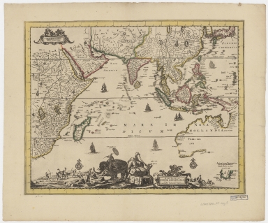
Nova tabula Indiae Orientalis
|
|
Original Title:
|
Nova tabvla Indiae Orientalis
|
|
Contributor:
|
Allard, Carel, 1648-approximately 1709
|
|
Category:
|
General Maps
|
|
Type:
|
Printed
|
|
Language:
|
Latin
|
|
Create Year:
|
1690-1710
|
|
Format:
|
JPEG, 16249 × 13515, 62.1MB
|
|
Scale:
|
ca. 1:5,500,000
|
|
Physical Map Dimension (cm):
|
42 × 52
|
|
Note:
|
Macao was marked on coast of Pearl River Estuary in this map.
|
|
Note:
|
Macao in Asia Maps; Macao in East Indies Maps
|
|
Geographic Area:
|
Asia
|
|
Geographic Area:
|
South Asia
|
|
Geographic Area:
|
Southeast Asia
|
|
Geographic Area:
|
Africa, East
|
|
Pub Title:
|
Nova tabula Indiae Orientalis
|
|
Pub Author:
|
Allard, Carel, 1648-approximately 1709
|
|
Pub Year:
|
1690-1710
|
|
Pub location:
|
Amsterdam
|
|
Provenance:
|
Harvard Map Collection - Harvard College Library
|
|
MUST holding:
|
http://10.20.100.239/record=b1347137
|