Detail View: Old Maps Collection: The Kingdom of Japan : divided into sixty-eight Provinces in all accuracy and carefully described and given according to the originally Japanese maps
|
Barcode:
|
4687820500397
|
|
Title:
|
The Kingdom of Japan : divided into sixty-eight Provinces in all accuracy and carefully described and given according to the originally Japanese maps
|
|
Original Title:
|
Het Koninkryk Japan : verdeelt in acht en zestig Provintien in alle Naauwkeurigheid en Zorgvuldigheid Beschreven en uytgegeven Volgens de Oorspronkelyke Japansche Kaarten
|
|
Other Title:
|
Kamtschatka : Door de Japonesers genaamt, oku Jeso, volgens de Nieuste Kaart van t'Russiche Ryk.
|
|
Other Title:
|
Niphon, of Noorderlyke Japansche Eilanden, en de Nabygelebe Eilanden by Jesogasima, benevens de zuyderlyke zee oevers, zo als ze Afgetekent zyn in een andere Japansche Kaart, in welke de Wegen door de Provintien, en de Naamen der Prinssen, Bevelhebbers en Overstens Naaukeurig afgebeeldt zynden.
|
|
Other Title:
|
Dsjusu of Paternoster der Japonesen.
|
|
Contributor:
|
Kaempfer, Engelbert, 1651-1716, author
|
|
Contributor:
|
Scheuchzer, John Gaspar, 1702-1729, author
|
|
Category:
|
General Maps
|
|
Type:
|
Printed
|
|
Language:
|
Dutch
|
|
Language:
|
Japanese
|
|
Create Year:
|
[ca. 1733]
|
|
Format:
|
JPEG 16100 × 13750, 60.5MB
|
|
Scale:
|
[ca. 1:3,250,000] (E 126°38'00"-E 146°01'00"/N 42°47'00"-N 23°37'00").
|
|
Physical Map Dimension (cm):
|
41 x 51 cm, on sheet 57 x 81 cm
|
|
Note:
|
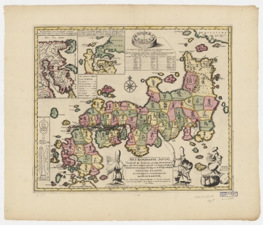
This map was prepared by from the maps brought back from Japan by Engelbert Kaempfer, a Swedish physician and diplomat. He visited Japan between 1690 and 1692 as part of the Dutch East India Company and was twice allowed to visit Edo (the former name of Tokyo). On the main map Japan is divided into 68 provinces, each with its Japanese name included in Japanese characters. As for the inset, the first one is of the Kamchatka Peninsula (Kamtschatka), Russia, and the second is of Northern Japan with part of Hokkaido (Jesogasima).
|
|
Note:
|
Inset 1: Kamtschatka : Door de Japonesers genaamt, oku Jeso, volgens de Nieuste Kaart van t'Russiche Ryk. - Scale not given. - 18 x 10 cm. -- Inset 2: Niphon, of Noorderlyke Japansche Eilanden, en de Nabygelebe Eilanden by Jesogasima, benevens de zuyderlyke zee oevers, zo als ze Afgetekent zyn in een andere Japansche Kaart, in welke de Wegen door de Provintien, en de Naamen der Prinssen, Bevelhebbers en Overstens Naaukeurig afgebeeldt zynden. - Scale not given. - 11 x 12 cm. -- Inset 3: Dsjusu of Paternoster der Japonesen. - Scale not given. - 16 x 3 cm.
|
|
Note:
|
Original is a copperplate printed map watercolored by hand, 41 x 51 cm.
|
|
Note:
|
Title cartouche sided by representation of two of the Seven Lucky Gods in Japanese mythology, on the left is Fukurokuju, credited with the ability to revive the dead, and on the right Ebisu, god of fishermen and luck. On the right bottom corner of the map there is Daikokuten, the god of great darkness or blackness. At the center on the upper part of the map there is a representation of a Chinese and Japanese sea compass rose. Inset 3 is the representation of five different juzu, as different Buddhist sects in Japan have different shaped juzus, and use them differently. There is an 8-point compass rose on the map with a fleur de lis indicating north and an arrow on the east point.
|
|
Note:
|
Relief shown pictorially.
|
|
Note:
|
Different administrative regions outlined in different colors.
|
|
Note:
|
Inset 2 with graticule.
|
|
Note:
|
The four borders of the map with latitude and longitude lines in black and white interchangeably.
|
|
Note:
|
Map and insets outlined in double fillet with border of the main map colored yellow.
|
|
Subject:
|
Administrative and political divisions
|
|
Geographic Area:
|
Japan
|
|
Geographic Area:
|
Kamchatka Peninsula (Russia)
|
|
Provenance:
|
Harvard Map Collection
|
|
Provenance:
|
http://id.lib.harvard.edu/alma/990125796160203941/catalog
|
|
Provenance Call No.:
|
G7961.F7 1733 .K3
|
|
MUST holding:
|
https://must.primo.exlibrisgroup.com/permalink/853MUST_INST/171sgkf/alma991000435579705076
|