Detail View: Old Maps Collection: A new map of the East India Isles from the latest authorities
|
Barcode:
|
4687820500396
|
|
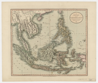
Title:
|
A new map of the East India Isles from the latest authorities
|
|
Original Title:
|
A new map of the East India Isles from the latest authorities
|
|
Contributor:
|
Cary, John, approximately 1754-1835
|
|
Category:
|
General Maps
|
|
Type:
|
Printed
|
|
Language:
|
English
|
|
Create Year:
|
1801
|
|
Format:
|
JPEG, 15806 × 13415, 61.7MB
|
|
Scale:
|
[ca. 1:9,000,000] (E 95°--E 135°/N 20°--S 10°)
|
|
Physical Map Dimension (cm):
|
44 × 50
|
|
Note:
|
Covers Sumatra, Java, Borneo, Suwalesi, the Philippines, Papua new Guinea and portions of China, Burma and Malaysia.
|
|
Note:
|
Macao was marked on coast of Pearl River Estuary in this map.
|
|
Note:
|
Macao in East Indies Maps
|
|
Geographic Area:
|
Southeast Asia
|
|
Geographic Area:
|
East Indies
|
|
Relation Note:
|
In Cary’s new universal atlas. 1808 Plate 44
|
|
Pub Title:
|
New universal atlas
|
|
Pub Author:
|
Cary, John, approximately 1754-1835
|
|
Pub Year:
|
1808
|
|
Pub location:
|
London
|
|
Provenance:
|
Harvard Map Collection - Harvard College Library
|