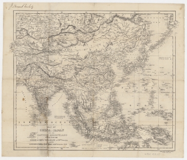
Detail View: Old Maps Collection: Map of China, Japan and the eastern archipelago : issued with the London & China Telegraph of 28th November and the London & China Express of 26th November 1859
|
Barcode:
|
4687820500394
|
|
Title:
|
Map of China, Japan and the eastern archipelago : issued with the London & China Telegraph of 28th November and the London & China Express of 26th November 1859
|
|
Original Title:
|
Map of China, Japan and the eastern archipelago : issued with the London & China Telegraph of 28th November and the London & China Express of 26th November 1859
|
|
Contributor:
|
Wyld, James, 1812-1887
|
|
Category:
|
Thematic Maps
|
|
Type:
|
Printed
|
|
Language:
|
English
|
|
Create Year:
|
1859
|
|
Format:
|
JPEG, 13814 × 11808, 55.3MB
|
|
Scale:
|
ca. 1:20,000,000 (E 64°26ʹ00ʺ--E 162°11ʹ00ʺ/N 56°37ʹ00ʺ--S 15°06ʹ00ʺ)
|
|
Physical Map Dimension (cm):
|
43 × 54
|
|
Note:
|
Shows electric telegraph lines, free ports of China and Japan. Includes notes. "London & China Telegraph. Nov. 28, 1859 London & China Express. Nov. 26, 1859"
|
|
Note:
|
Macao and the surrounding islands were depicted in this map.
|
|
Note:
|
Macao in East Indies Maps; Macao in Asia Maps
|
|
Subject:
|
Telegraph
|
|
Subject:
|
Express service
|
|
Geographic Area:
|
Asia
|
|
Geographic Area:
|
China
|
|
Geographic Area:
|
Japan
|
|
Geographic Area:
|
India
|
|
Geographic Area:
|
Indonesia
|
|
Pub Title:
|
Map of China, Japan and the eastern archipelago : issued with the London & China Telegraph of 28th November and the London & China Express of 26th November 1859
|
|
Pub Author:
|
Wyld, James, 1812-1887
|
|
Pub Year:
|
[1859]
|
|
Pub location:
|
[London]
|
|
Provenance:
|
Harvard Map Collection - Harvard College Library
|