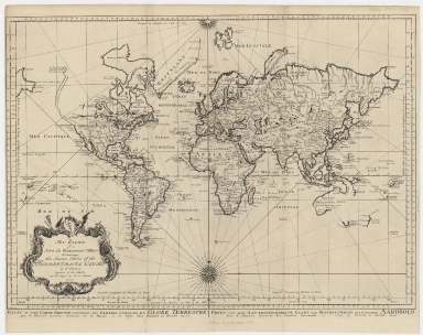
Detail View: Old Maps Collection: An essay of a new and compact map containing the known parts of the terrestrial globe = Essay d’une carte reduite contenant les parties connues du globe terrestre = Proef van eene aan-eengeschakelde kaart der bekende-deelen des gantschen aardbols
|
Barcode:
|
4687820500386
|
|
Title:
|
An essay of a new and compact map containing the known parts of the terrestrial globe = Essay d’une carte reduite contenant les parties connues du globe terrestre = Proef van eene aan-eengeschakelde kaart der bekende-deelen des gantschen aardbols
|
|
Original Title:
|
An essay of a new and compact map containing the known parts of the terrestrial globe = Essay d’une carte reduite contenant les parties connues du globe terrestre = Proef van eene aan-eengeschakelde kaart der bekende-deelen des gantschen aardbols
|
|
Contributor:
|
Bellin, Jacques Nicolas, 1703-1772
|
|
Contributor:
|
Hondt, Pieter de
|
|
Contributor:
|
Schley, Jacobus van der, 1715-1779
|
|
Category:
|
Sea Charts
|
|
Type:
|
Printed
|
|
Language:
|
English
|
|
Create Year:
|
1750
|
|
Format:
|
JPEG, 16752 × 13297, 67.4MB
|
|
Scale:
|
[ca. 1:60,000,000] (W 180⁰--E 180⁰/N 90⁰--S 90⁰)
|
|
Physical Map Dimension (cm):
|
50 × 69
|
|
Note:
|
Prime meridians: Paris and Ferro. Title cartouche. In lower corner: "J. v. Schley, direx."
|
|
Note:
|
Macao was marked in the middle of Pearl River Estuary in this map.
|
|
Note:
|
Macao in World Maps
|
|
Subject:
|
Nautical charts
|
|
Geographic Area:
|
World
|
|
Pub Title:
|
An essay of a new and compact map containing the known parts of the terrestrial globe = Essay d’une carte reduite contenant les parties connues du globe terrestre = Proef van eene aan-eengeschakelde kaart der bekende-deelen des gantschen aardbols
|
|
Pub Author:
|
Bellin, Jacques Nicolas, 1703-1772
|
|
Pub Year:
|
1750
|
|
Pub location:
|
Hague
|
|
Provenance:
|
Harvard Map Collection - Harvard College Library
|