Detail View: Old Maps Collection: Chart of the coast of China to the eastward of the great Ladrone
|
Barcode:
|
4687820500373
|
|
Title:
|
Chart of the coast of China to the eastward of the great Ladrone
|
|
Contributor:
|
Ross, Daniel, 1780-1849, cartographer
|
|
Contributor:
|
Horsburgh, James, 1762-1836, publisher
|
|
Category:
|
Sea Charts
|
|
Type:
|
Printed
|
|
Language:
|
English
|
|
Create Year:
|
1814
|
|
Format:
|
JPEG 18264 × 12985, 59.6MB
|
|
Scale:
|
Scale not given (E 113°56ʹ23ʺ--E 114°24ʹ25ʺ/N 22°33ʹ43ʺ--N 22°11ʹ06ʺ)
|
|
Physical Map Dimension (cm):
|
47 x 70 cm, on sheet 55 x 79 cm
|
|
Note:
|
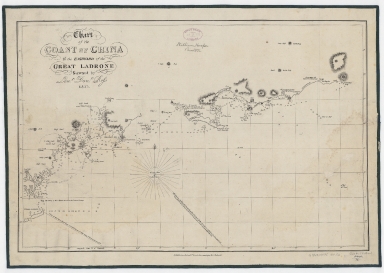
This hydrographic chart depicts the coast of South China extending from the Lamma Island (Lemma Channel) to Gangliao Bay. The outline of the coasts is somewhat accurate, however, the west part is much more detailed with a lot of soundings given while east the detail and soundings decrease which demotes that the surveying was underdeveloped in those areas. As the chart was to be used mostly for navigation there are quite a few navigational aid notes and a lot of Pagodas, Forts and mountains that can be seen from the sea are marked on the map.
|
|
Note:
|
Original is a copperplate printed map, 45 x 69 cm.
|
|
Note:
|
There is a 32-point compass rose with a fleur de lis indicating north.
|
|
Note:
|
Relief shown by hachures and bathymetric relief by soundings.
|
|
Note:
|
Three borders of the map with latitude and longitude lines, left, bottom and right.
|
|
Note:
|
Map with graticule.
|
|
Note:
|
Map outlined in double fillet.
|
|
Subject:
|
Coasts
|
|
Subject:
|
Nautical charts
|
|
Geographic Area:
|
China
|
|
Provenance:
|
Harvard Map Collection
|
|
Provenance:
|
http://id.lib.harvard.edu/alma/990138605770203941/catalog
|
|
Provenance Call No.:
|
G7823.H45P5 1814 .R6
|
|
MUST holding:
|
https://must.primo.exlibrisgroup.com/permalink/853MUST_INST/171sgkf/alma991002992049605076
|