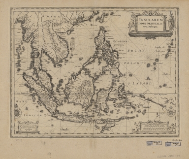
Detail View: Old Maps Collection: Insularum Indiae Orientalis : nova descriptio
|
Barcode:
|
4687820500371
|
|
Title:
|
Insularum Indiae Orientalis : nova descriptio
|
|
Original Title:
|
Insularum Indiae Orientalis : nova descriptio
|
|
Contributor:
|
Jansson, Jan, 1588-1664
|
|
Category:
|
Sea Charts
|
|
Type:
|
Printed
|
|
Language:
|
latin
|
|
Create Year:
|
1650?
|
|
Format:
|
JPEG, 14534 × 12470, 57.7MB
|
|
Scale:
|
[ca. 1:12,000,000] (E 82⁰04ʹ33ʺ--E 155⁰08ʹ15ʺ/N 30⁰19ʹ54ʺ--S 23⁰18ʹ55ʺ)
|
|
Physical Map Dimension (cm):
|
37 × 48
|
|
Note:
|
Covers Sumatra, Java, Borneo, Suwalesi, the Philippines, Papua New Guinea and portions of China, Burma and Malaysia.
|
|
Note:
|
This is an early old map depicted the world and the East Asia before the Portuguese established the permanent settlement in Macao
|
|
Note:
|
Macao in East Indies Maps
|
|
Subject:
|
Nautical charts
|
|
Geographic Area:
|
Southeast Asia
|
|
Geographic Area:
|
East Indies
|
|
Pub Title:
|
Insularum Indiae Orientalis : nova descriptio
|
|
Pub Author:
|
Jansson, Jan, 1588-1664
|
|
Pub Year:
|
[1650?]
|
|
Pub location:
|
Amsterdam
|
|
Provenance:
|
Harvard Map Collection - Harvard College Library
|
|
MUST holding:
|
http://10.20.100.239/record=b1347138
|