Detail View: Old Maps Collection: The kingdom of China
|
Barcode:
|
3687800301586C
|
|
Title:
|
The kingdom of China
|
|
Original Title:
|
The kingdome of China
|
|
Contributor:
|
Speed, John, ca. 1552-1629, cartographer
|
|
Contributor:
|
Dawson, John, d. 1634?, printer
|
|
Contributor:
|
Humble, George, 15---1640, bookseller
|
|
Category:
|
General Maps
|
|
Type:
|
Printed
|
|
Language:
|
English
|
|
Language:
|
Portuguese
|
|
Language:
|
Spanish
|
|
Create Year:
|
1626
|
|
Format:
|
JPEG 13371 × 10033, 51.2MB
|
|
Scale:
|
[ca. 1:5,000,000] (E 105⁰--W 173⁰/N 62⁰30ʹ--N 15⁰30ʹ).
|
|
Physical Map Dimension (cm):
|
40 x 52 cm
|
|
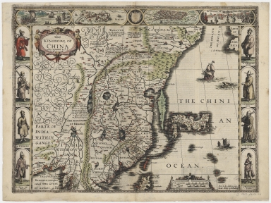
Note:
|
John Speed was an English historian and mapmaker who had connections with the 'Society of Antiquaries' where he had contact with scholars. In 1627 Speed published the work 'A prospect of the most famous parts of the world' in which this map is included with descriptive text on the back. This was one of the first maps of China in English. The map follows the 'Barbuda model' -from the map of China by the Portuguese cartographer Luís Jorge de Barbuda published in Ortelius 'Theatrum Orbis Terrarum'- but with Japan in the already 'Teixeira's type' -from the Japan map by Portuguese cartographer Luís Teixeira also published in Ortelius atlas. Korea is still depicted as an island, again as in the Japan map by Teixeira in Ortelius atlas. Eastern India is displayed on the left of the map, with the Ganges region, extending well into Central Asia. Many of the notes on China are both historical and mythical. In the Macao inset -copied from De Bry- the city is surround by vessels on almost all sides, there are ships in the inner harbor, showing it as a prosperous shipping port. The lighthouse, churches and many European buildings are depicted to explain the Macao of the time. Being depicted only Macao and the capital city in East China demonstrates the great importance of Macao to western knowledge about China.
|
|
Note:
|
Original is a copperplate printed map water colored by hand, 35 x 43 cm, on sheet 42 x 56 cm.
|
|
Note:
|
On the top bordure of the map there are four insets: the first with wheeled wind machines as a means of traveling; the second and third views of Macao and 'Quinzay' -today Hangzhou- and lastly a representation of the persecution of Christians in Japan. Between the views of the cities there is a coat of arms left black. On each side of the map there are illustrations of the inhabitants of China and 'Pegu' -today Myanmar- both men and women, there are also Japanese warriors in one of the earliest depictions in an European map. On water masses there are two vessels, one is a junk and the other a masted sailing vessel, it can also be seen a sea monster.
|
|
Note:
|
Title and scale line inside strapwork cartouches, the first with feminine figures on each side and the latter with phytomorphic motifs.
|
|
Note:
|
Double scale line in germanic and english miles.
|
|
Note:
|
Relief shown pictorially.
|
|
Note:
|
Latitude lines on both sides of the map in black and white interchangeably.
|
|
Note:
|
Map outlined in border with semi circles.
|
|
Note:
|
Macao in China Maps.
|
|
Note:
|
City plans of Macao.
|
|
Note:
|
Title, scale line, notes, land and water masses in English with place names in Portuguese and Spanish.
|
|
Reference:
|
Tooley's Dic. of Mapmakers, Q-Z [vol. 4], p. 193
|
|
Reference:
|
NLA https://catalogue.nla.gov.au/Record/3081294
|
|
Reference:
|
University of Southern California http://digitallibrary.usc.edu/cdm/compoundobject/collection/p15799coll71/id/208
Collection Path
|
|
Geographic Area:
|
China
|
|
Geographic Area:
|
Japan
|
|
Geographic Area:
|
Korea
|
|
Geographic Area:
|
Macao (China)
|
|
Geographic Area:
|
Pegu (Burma)
|
|
Pub Title:
|
A prospect of the most famous parts of the world
|
|
Pub Author:
|
Speed, John, ca. 1552-1629
|
|
Pub Year:
|
1627
|
|
Pub location:
|
London
|
|
Provenance:
|
Harvard College Library
|
|
Provenance:
|
http://id.lib.harvard.edu/alma/990125244810203941/catalog
|
|
Provenance Call No.:
|
MAP-LC (G7810 1626 .S6)
|
|
MUST holding:
|
https://must.primo.exlibrisgroup.com/permalink/853MUST_INST/reglfj/alma991000205989705076
|