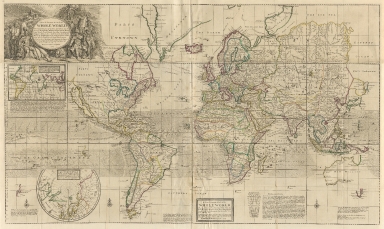
Detail View: Old Maps Collection: A new & correct map of the whole world

|
Barcode:
|
4687820500363
|
|
Title:
|
A new & correct map of the whole world
|
|
Original Title:
|
A new & correct map of the whole world
|
|
Contributor:
|
Moll, Herman, -1732
|
|
Category:
|
General Maps
|
|
Type:
|
Printed
|
|
Language:
|
English
|
|
Create Year:
|
1719
|
|
Format:
|
JPEG, 14702 × 8772, 52.1MB
|
|
Scale:
|
[ca. 1:33,000,000]
|
|
Physical Map Dimension (cm):
|
73 x 121
|
|
Note:
|
Projection mention in titles : "The Projection of this Map is called Mercator's the Designe is to make it Useful both for Land and Sea."
|
|
Note:
|
Macao and the surrounding islands were depicted in this map.
|
|
Note:
|
Macao in World Maps
|
|
Subject:
|
Trade winds
|
|
Geographic Area:
|
World
|
|
Pub Title:
|
The world described : or, a new and correct sett of maps: shewing the several empires, kingdoms, republics...in all the known parts of the earth.
|
|
Pub Author:
|
Moll, Herman, -1732
|
|
Pub Year:
|
[1709-1720]
|
|
Pub location:
|
[London]
|
|
Provenance:
|
Houghton Library - Harvard College Library
|
|
MUST holding:
|
http://10.20.100.239/record=b1390038
|