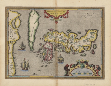
Detail View: Old Maps Collection: A representation of the island of Japan by Luis Teixeira
|
Barcode:
|
4687820500359
|
|
Title:
|
A representation of the island of Japan by Luis Teixeira
|
|
Original Title:
|
Iaponiae insvlae descriptio
|
|
Other Title:
|
Japoniae insulae descriptio
|
|
Contributor:
|
Teixeira, Luís, 1564-1604, cartographer
|
|
Category:
|
General Maps
|
|
Type:
|
Printed
|
|
Language:
|
Latin
|
|
Create Year:
|
1595
|
|
Format:
|
JPEG 13516 × 10883, 53.2MB
|
|
Scale:
|
[ca. 1:4,800,000]
|
|
Physical Map Dimension (cm):
|
32 × 45
|
|
Note:
|
"Cum Imperatorio, Regio, et Brabantiae privilegio decennali, 1595"--upper right.
|
|
Geographic Area:
|
Japan
|
|
Relation Note:
|
From: Abraham Ortelius’ Theatrum orbis terrarum. London, I. Norton, 1606. (p. [106]-107)
|
|
Pub Title:
|
Theatrum orbis terrarum
|
|
Pub Author:
|
Ortelius, Abraham, 1527-1598
|
|
Pub Year:
|
[1606]
|
|
Pub location:
|
[London]
|
|
Provenance:
|
Harvard Map Collection - Harvard College Library
|