Detail View: Old Maps Collection: Isola del Giappone e penisola di Corea
|
Barcode:
|
4687820500326
|
|
Title:
|
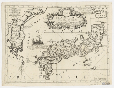
Isola del Giappone e penisola di Corea
|
|
Contributor:
|
Coronelli, Vincenzo, 1650-1718, cartographer
|
|
Contributor:
|
Padoani, Domenico, fl. 16--, printer, bookseller
|
|
Contributor:
|
Fontaine, Paolo, dedicatee
|
|
Category:
|
Sea Charts
|
|
Type:
|
Printed
|
|
Language:
|
Italian
|
|
Language:
|
French
|
|
Language:
|
Dutch
|
|
Create Year:
|
[ca. 1692]
|
|
Format:
|
JPEG 15995 × 12337, 53.4MB
|
|
Scale:
|
[ca. 1:3,400,000]
|
|
Physical Map Dimension (cm):
|
45 x 61 cm, on sheet 57 x 71 cm
|
|
Note:
|
Vincenzo Maria Coronelli is considered one of the most great, hard-working and famous Italian cartographers. He was responsible for many geographic works such as the 'Atlante Veneto', the 'Isolario', the 'Universal Course', the 'Singularities of Venice', and the book of the globes. This map depicts Japan and the Korean Peninsula and it seems to have been drawn according to the Blaeu-Martini model with other Jesuit sources. Great detail is given already to place names in Japan however very few are still known in Korea. The map depicts the administrative divisions, cities, villages, rivers and mountains.
|
|
Note:
|
Original is a copper plate printed map, 44 x 59 cm.
|
|
Note:
|
Title in phytomorphic cartouche with the monogram from the Society of Jesus on top. There are two 16-point compass rose on the map with a fleur de lis indicating north, the one on the left side of he map with the cardinal points names in Italian. The rhumb lines for the principal winds is dotted and for the half-winds is dashed. There is a representation of a Japanese vessel on the map with a legend underneath that describes it. It is called 'Tayfena' and very fast, so that can travel from Osaka to Nagasaki in 12 days at the a speed of 220 French nautical leagues.
|
|
Note:
|
Six scale lines on the left upper corner of the map in black and white interchangeably.
|
|
Note:
|
Relief shown pictorially.
|
|
Note:
|
Map with graticule.
|
|
Note:
|
The four borders of the map with latitude and longitude lines and labelled with North, South, East and West in Italian Settentrion, Mezo Giorno, Oriente and Occidente.
|
|
Reference:
|
Mapping Japan: the Jason C. Hubbard Collection, part one, p. 107-[108]
|
|
Reference:
|
Hubbard, J.C. Japoniae Insulae: the mapping of Japan, map 57, p. 257-259
|
|
Reference:
|
Cortazzi, H. Isles of Gold:antique maps of Japan, map 75, p. 48
|
|
Reference:
|
Campbell, T. Japan: European printed maps to 1800, map 33
|
|
Geographic Area:
|
Japan
|
|
Geographic Area:
|
Korea
|
|
Geographic Area:
|
East Asia
|
|
Provenance:
|
Harvard College Library
|
|
Provenance:
|
http://id.lib.harvard.edu/alma/990125783560203941/catalog
|
|
Provenance Call No.:
|
G7960 1692 .C6
|
|
MUST holding:
|
https://must.primo.exlibrisgroup.com/permalink/853MUST_INST/171sgkf/alma991002984149805076
|