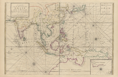
Detail View: Old Maps Collection: Carte des costes de l'Asie sur l'Ocean : contenant les bancs isles et costes & c, levee sur les memoires les plus nouveau

|
Barcode:
|
4687820500350
|
|
Title:
|
Carte des costes de l'Asie sur l'Ocean : contenant les bancs isles et costes & c, levee sur les memoires les plus nouveau
|
|
Original Title:
|
Carte des costes de l'Asie sur l'Ocean : contenant les bancs isles et costes & c, levee sur les memoires les plus nouveau
|
|
Contributor:
|
Mortier, Pierre, 1661-1711
|
|
Category:
|
Sea Charts
|
|
Type:
|
Printed
|
|
Language:
|
French
|
|
Create Year:
|
1700
|
|
Format:
|
JPEG, 12718 × 7881, 36.4MB
|
|
Scale:
|
[ca. 1:14 000 000]
|
|
Physical Map Dimension (cm):
|
57 × 87
|
|
Note:
|
Map of south-east Asia and the Far East on two joined sheets. "Partie orientale de l'Asie sur l'ocean." Inset: [Nouvelle Hollande]
|
|
Note:
|
Macao and the surrounding islands were depicted in this map.
|
|
Note:
|
Macao and its Surroundings
|
|
Note:
|
Macao in Asia Maps
|
|
Subject:
|
Nautical charts
|
|
Geographic Area:
|
Southeast Asia
|
|
Geographic Area:
|
East Asia
|
|
Geographic Area:
|
Pacific Ocean
|
|
Geographic Area:
|
Indian Ocean
|
|
Relation Note:
|
From: Suite du Neptune Francois. Amsterdam : Chez Pierre Mortier, Libraire, [1700?]
|
|
Pub Title:
|
Suite du Neptune françois, ou Atlas nouveau des cartes marines.
|
|
Pub Author:
|
Frémónt d’Ablancourt, Jean Jacobé de, 1621-1696
|
|
Pub Year:
|
1700
|
|
Pub location:
|
Amsterdam
|
|
Provenance:
|
Harvard Map Collection - Harvard College Library
|
|
MUST holding:
|
http://10.20.100.239/record=b1389970
|