Detail View: Old Maps Collection: Nova totius terrarum orbis tabula
|
Barcode:
|
4687820500346
|
|
Title:
|
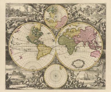
Nova totius terrarum orbis tabula
|
|
Original Title:
|
Nova totius terrarum orbis tabula
|
|
Contributor:
|
Renard, Louis
|
|
Category:
|
Hemispheres
|
|
Type:
|
Printed
|
|
Language:
|
French
|
|
Create Year:
|
1715?
|
|
Format:
|
JPEG, 9684 × 8000, 37.2MB
|
|
Scale:
|
Scale not given
|
|
Physical Map Dimension (cm):
|
46 x 64
|
|
Note:
|
28 of the plates are folding maps, hand colored. Emblematic frontispiece (also hand colored): Planisphere representant toute l’entendue du monde dans l’ordre qu’on a suive dans ce livre. Four plates at the end of the atlas contain drawings and plans of fortifications with explanations. Shows world in hemispheres with insets of north and south polar regions.
|
|
Subject:
|
Geography
|
|
Geographic Area:
|
World
|
|
Pub Title:
|
Atlas de la navigation et du commerce qui se fait dans toutes les parties du monde ...
|
|
Pub Author:
|
Renard, Louis
|
|
Pub Year:
|
1715
|
|
Pub location:
|
Amsterdam
|
|
Provenance:
|
Houghton Library - Harvard College Library
|