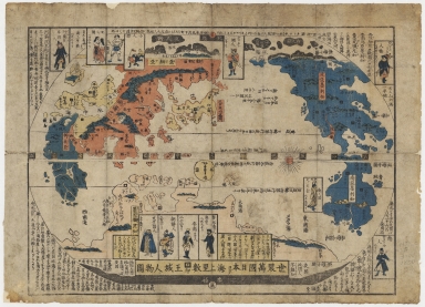
Detail View: Old Maps Collection: 世界萬國日本ヨリ海上里数国印王城人物圖 = Sekai bankoku Nihon yori kaijō risu kokuin ōjō jinbutsuzu

|
Barcode:
|
4687820500345
|
|
Title:
|
世界萬國日本ヨリ海上里数国印王城人物圖 = Sekai bankoku Nihon yori kaijō risu kokuin ōjō jinbutsuzu
|
|
Original Title:
|
世界萬國日本ヨリ海上里数国印王城人物圖 = Sekai bankoku Nihon yori kaijō risu kokuin ōjō jinbutsuzu
|
|
Contributor:
|
Anonymous
|
|
Category:
|
General Maps
|
|
Type:
|
Printed
|
|
Language:
|
Japanese
|
|
Create Year:
|
1850?
|
|
Format:
|
JPEG, 11957 × 8638, 37.9MB
|
|
Page No.:
|
1
|
|
Scale:
|
Scale not given
|
|
Physical Map Dimension (cm):
|
44 × 32
|
|
Note:
|
This map, published in the late Edo period, was one of many variations based on the original version of the Matteo Ricci series of maps of the world. This map shows the shape of the continents much simplified. The map prospectus shows people of different countries in various poses. It includes a fictitious country that is far from Japan and easy to see. Wood block print. Includes text.
|
|
Geographic Area:
|
World
|
|
Pub Title:
|
世界萬國日本ヨリ海上里数国印王城人物図 = Sekai bankoku Nihon yori kaijō risu kokuin ōjō jinbutsuzu
|
|
Pub Year:
|
[1850?]
|
|
Pub location:
|
[Japan]
|
|
Provenance:
|
Harvard Map Collection - Harvard College Library
|
|
MUST holding:
|
http://10.20.100.239/record=b1407558
|