Detail View: Old Maps Collection: L'empire de la Chine pour servir a l'Histoire generale des voyages = Keizerryk van China, om te dienen tot de Historische Beschryving der Reizen
|
Barcode:
|
4687820500344
|
|
Title:
|
L'empire de la Chine pour servir a l'Histoire generale des voyages = Keizerryk van China, om te dienen tot de Historische Beschryving der Reizen
|
|
Original Title:
|
L’empire de la Chine pour servir a l’Histoire generale des voyages = Keizerryk van China, om te dienen tot de Historische Beschryving der Reizen
|
|
Contributor:
|
Bellin, Jacques Nicolas, 1703-1772
|
|
Contributor:
|
Schley, Jacobus van der, 1715-1779
|
|
Category:
|
General Maps
|
|
Type:
|
Printed
|
|
Language:
|
French
|
|
Create Year:
|
1748
|
|
Format:
|
JPEG, 13525 × 10639, 38.8MB
|
|
Scale:
|
approximately 1:10,000,000 (E 73°29ʹ00ʺ--E 134°46ʹ00ʺ/N 53°33ʹ00ʺ--N 18°09ʹ00ʺ)
|
|
Physical Map Dimension (cm):
|
27.2 × 38.7
|
|
Note:
|
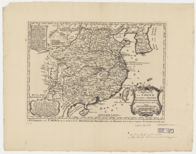
Includes notes in French and Dutch on the background of the map. Sea of Korea referred to as "Mer de Corée;" Korea as "Royaume de Corée.
|
|
Note:
|
In this map, Macao is in the center of the mouth of the Pearl River estuary. Macao and the surrounding islands were depicted in this map.
|
|
Note:
|
The map was drawn by Jacques Nicolas Bellin who was the French naval hydrologist and chief cartographer.
|
|
Note:
|
Macao in China Maps
|
|
Geographic Area:
|
China
|
|
Geographic Area:
|
Korea
|
|
Relation Note:
|
Appears in: Histoire générale des voyages, ou Nouvelle collection de toutes les relations de voyages par mer et par terre. / Antoine François Prévost [et al.]. La Haye : P. de Hondt,1747-1767. (Vol. 8, p. 1)
|
|
Pub Title:
|
L’Histoire générale des voyages
|
|
Pub Author:
|
Prévost, abbé, 1697-1763
|
|
Pub Year:
|
[1749]
|
|
Pub location:
|
[Hague]
|
|
Provenance:
|
Harvard Map Collection - Harvard College Library
|