Detail View: Old Maps Collection: Canton and its approaches, Macao and Hong Kong
|
Barcode:
|
4687820500043
|
|
Title:
|
Canton and its approaches, Macao and Hong Kong
|
|
Other Title:
|
Macao.
|
|
Other Title:
|
Hong Kong surveyed by Capt. Sir E. Belcher R.N.
|
|
Other Title:
|
Sketch of the river from Macao to Canton.
|
|
Other Title:
|
Canton.
|
|
Contributor:
|
Belcher, Edward, Sir, 1799-1877, cartographer
|
|
Contributor:
|
Cox, George, publisher
|
|
Contributor:
|
Society for the Diffusion of Useful Knowledge (Great Britain), creator
|
|
Category:
|
City Plans & Views
|
|
Type:
|
Printed
|
|
Language:
|
English
|
|
Create Year:
|
1853
|
|
Format:
|
JPEG 10422 × 8687, 92.6MB
|
|
Page No.:
|
170
|
|
Scale:
|
Scales vary.
|
|
Physical Map Dimension (cm):
|
33 x 39 cm
|
|
Note:
|
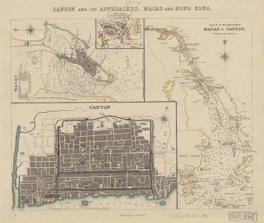
The map is made according to the studies of Edward Belcher a British hydrographer, Royal Navy officer and explorer. He is known for making the first British survey of Hong Kong harbour and is commemorated in Hong Kong through Belcher's Street, Belcher Bay and The Belcher's in Kennedy Town. This map is divided in three big sections depicting the areas of the Guangzhou Region, China. The first section is a map of Macao with a small inset of the city of Hong Kong. The second is the Pearl River as it runs from Macao and Lantao to Canton, covering the whole Pearl River Delta. And the third is a map of Canton. Both Macao and Canton are fairly detailed and show major landmarks and streets -on Canton the foreign factories are watercolored in yellow. The map is noteworthy as one of the earliest separate appearances of Hong Kong on a printed map. This inset mentions Point Albert which is a coastal fortification no longer existing, demolish ca. 1888 that would later become Wellington Battery and then Tamar. The map appears in 'General atlas published under the superintendence of the Society for the Diffusion of Useful Knowledge', vol. 2, map no. 170a; to which are known editions from 1852-1854 by publisher George Cox, who purchased the Society for the Diffusion of Useful Knowledge plates from Charles Knight in 1852.
|
|
Note:
|
Map 1: Macao. - Scale indeterminable. - 13 x 21 cm. -- Inset 1: Hong Kong surveyed by Capt. Sir E. Belcher R.N. - Scale [ca. 1:251,300]. - 5 x 8 cm. -- Map 2: Sketch of the river from Macao to Canton : soundings are in fathoms. - Scale not given. - 30 x 17 cm. -- Map 3: Canton. - Scale [ca. 1:460,800]. - 17 x 26 cm.
|
|
Note:
|
Original is a map formed by 3 maps, steel engraved and hand colored.
|
|
Note:
|
The Macao and the Pearl River maps have depth sounding marked in feet and fathoms respectively. The Canton map shows bathymetric relief both as gradient tints and isolines. The Hong Kong inset has hachure relief.
Each map -including the inset of Hong Kong- has a compass rose indicating north.
|
|
Note:
|
At bottom right side of the sheet: 170a.
|
|
Note:
|
Macao in Routes.
|
|
Note:
|
Macao and its Surroundings.
|
|
Note:
|
City Plans of Macao.
|
|
Reference:
|
Tooley's dictionary of map makers, [1] A-D, p. 309
|
|
Reference:
|
Phillips, P.L. A list of geographical atlases in the Library of Congress, vol. I, p. 481
|
|
Geographic Area:
|
Macao (China)
|
|
Geographic Area:
|
Hong Kong (China)
|
|
Geographic Area:
|
Guangzhou Shi (China)
|
|
Geographic Area:
|
Pearl River Estuary (China)
|
|
Relation Note:
|
Vol. 2, map no. 170 a.
|
|
Pub Title:
|
General atlas published under the superintendence of the Society for the Diffusion of Useful Knowledge.
|
|
Pub Year:
|
1853
|
|
Pub location:
|
London
|
|
Provenance:
|
Harvard College Library
|
|
Provenance:
|
http://id.lib.harvard.edu/alma/990125229630203941/catalog
|
|
Provenance Call No.:
|
MAP-LC G7822.P4 1853 .B4
|
|
MUST holding:
|
https://must.primo.exlibrisgroup.com/permalink/853MUST_INST/171sgkf/alma991000324639705076
|