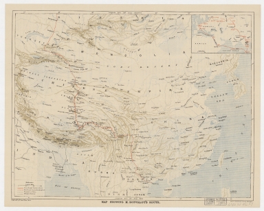
Detail View: Old Maps Collection: Map showing M. Bonvalot's route

|
Barcode:
|
4687820500335
|
|
Title:
|
Map showing M. Bonvalot's route
|
|
Other Title:
|
[Complete Route]
|
|
Contributor:
|
Erhard Bros. (Firm), engraver
|
|
Category:
|
Thematic Maps
|
|
Type:
|
Printed
|
|
Language:
|
English
|
|
Create Year:
|
[ca. 1892]
|
|
Format:
|
JPEG 12293 × 9863, 33.8MB
|
|
Scale:
|
[ca. 1:10,000,000] (E 72°34ʹ00ʺ--E 130°12ʹ00ʺ/N 52°35ʹ00ʺ--N 18°02ʹ00ʺ).
|
|
Physical Map Dimension (cm):
|
37 x 48 cm, on sheet 44 x 56 cm
|
|
Note:
|
Pierre Gabriel Édouard Bonvalot (1853-1933) was a French explorer of Central Asia and Tibet. Bonvalot was accompanied in his travels by a Belgian missionary, Father De Deken (1852-1896), who spoke Chinese and joined the expedition to reach Shanghai with his Chinese servant, an Uzbek assistant, Rachmed, who joined the expedition in Russia, Abdoullah a translator, and Prince Henri of Orléans (1867-1901), who acted as his photographer and botanist. The original plan was to cross Asia and reach Tonkin in French Indochina. The expedition began with relative comfort until they reached the border between Russian and Chinese Turkestan. The group crossed into Chinese controlled territory, then had to spend the winter in Tibet. The group then continued traveling across the Tibetan Plateau to its eastern extremities, reaching Kangding in Qing controlled territory, in June and finally Hanoi in late September 1890. In the map the route is divided in two, through territories already explored by westerns and territories yet not explored, interchanging between each other.
|
|
Note:
|
Inset 1: [Complete Route]. - Scale indeterminable. - 8 x 12 cm.
|
|
Note:
|
Original is a colored printed map, 38 x 48 cm.
|
|
Note:
|
On the left bottom corner of the map: "Engraved by Erhard Bros. Paris."
|
|
Note:
|
Scale line in English miles on the legend cartouche on the left bottom corner of the map.
|
|
Note:
|
The four borders of the map with latitude and longitude lines.
|
|
Note:
|
Map outlined in simple bold fillet and inset inside double fillet.
|
|
Note:
|
Macao in China maps.
|
|
Subject:
|
Discoveries in geography
|
|
Subject:
|
Bonvalot, Gabriel, 1853-1933
|
|
Geographic Area:
|
China
|
|
Geographic Area:
|
South China Sea
|
|
Geographic Area:
|
Myanmar
|
|
Geographic Area:
|
Korea
|
|
Geographic Area:
|
Hainan Sheng (China)
|
|
Geographic Area:
|
Taiwan
|
|
Geographic Area:
|
India
|
|
Geographic Area:
|
Bay of Bengal
|
|
Geographic Area:
|
Mongolia
|
|
Geographic Area:
|
Philippines
|
|
Provenance:
|
Harvard Map Collection
|
|
Provenance:
|
http://id.lib.harvard.edu/alma/990138226390203941/catalog
|
|
Provenance Call No.:
|
G7821.S12 1892 .E7
|
|
MUST holding:
|
https://must.primo.exlibrisgroup.com/permalink/853MUST_INST/171sgkf/alma991002990748805076
|