Detail View: Old Maps Collection: Imperium Japonicum per regiones digestum sex et sexaginta atque ex ipsorum Japonensium mappis descriptum
|
Barcode:
|
4687820500383
|
|
Title:
|
Imperium Japonicum per regiones digestum sex et sexaginta atque ex ipsorum Japonensium mappis descriptum
|
|
Original Title:
|
Imperivm Japonicvm per regiones digestvm sex et sexaginta atqve ex ipsorvm Japonensivm mappis descriptvm
|
|
Other Title:
|
Conspectus urbis Nangasacki, et Insulae ante illam sitae, in qua sedes est Batavorum
|
|
Contributor:
|
Reelant, Adriaan, 1676-1718, cartographer
|
|
Contributor:
|
Ottens, Reinier, 1698-1750, printer
|
|
Contributor:
|
Ottens, Josua, 1704-1765, printer
|
|
Contributor:
|
Goeree, Jan, 1670-1731, illustrator
|
|
Contributor:
|
Ruyter, Baltasar, fl. 1700-1730, engraver
|
|
Contributor:
|
Bignon, Jean-Paul, 1662-1743, dedicatee
|
|
Category:
|
General Maps
|
|
Type:
|
Printed
|
|
Language:
|
Latin
|
|
Language:
|
Dutch
|
|
Language:
|
Japanese
|
|
Create Year:
|
[ca. 1756]
|
|
Format:
|
JPEG 10413 × 8000, 36MB
|
|
Scale:
|
[ca. 1:2,250,000].
|
|
Physical Map Dimension (cm):
|
48 x 58 cm, on sheet 57 x 73 cm
|
|
Note:
|
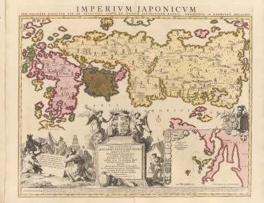
This map was the first map to use Sino-Japanese characters on a European printed map. The sources of this map were mainly Japanese maps, most notably a map from the library or Benjamin Dutry (fl. 1742-1752), a former director of the Dutch East India Company. Although for the Nagasaki inset the sources are still mainly from cumulative European knowledge. Honshu the main Japanese island -here named simply Nipon, Japan- is in a distorted view because the geographical shape was made to fit the format of the map and so represents a step backwards in the depiction of this particular island in European cartography. However, Kyushu -spelled Kioesioe on the map- is very accurate and its depiction is not surpassed in European maps until the 19th century. Another improvement is the Sino-Japanese characters and the removal of many fictitious places.
|
|
Note:
|
Inset 1: Conspectus urbis Nangasacki, et Insulae ante illam sitae, in qua sedes est Batavorum. - Scale indeterminable. - 14 x 21 cm.
|
|
Note:
|
Original is a copper plate printed map colored by hand, 44 x 59 cm.
|
|
Note:
|
On the right bottom corner of the dedicatee cartouche: "J. Goeree in.". And on the right bottom corne of the map: "B. Ruyter sculp."
|
|
Note:
|
On the bottom center of the map there is a dedication to Jean-Paul Bignon inside a cartouche with a miter and the coat of arms of the dedicatee on top sided by two angels. Examples of Japanese ceramics that were a popular import to the Netherlands are displayed at the base of the cartouche. On the left of the cartouche there is a representation of natives, Samurai merchants and farmers with a Pagoda on the back and on the right side are represented fisherman and a Japanese junk. On the inset of Nagasaki can be seen 20 medallions with the coats of arms of Japanese noble families with a bigger one on the right upper side of the Japanese Empire with an unidentified portrait. There is a 4-point compass rose on the map with a fleur de lis indicating north.
|
|
Note:
|
Both scales lines for the main map and the inset on the left bottom corner of their respective map. In German miles in black and white interchangeably.
|
|
Note:
|
Relief shown pictorially. And bathymetric soundings on the inset.
|
|
Note:
|
Land masses and islands outlined and colored in different colors.
|
|
Note:
|
The four borders of the map with latitude and longitude lines in black and white interchangeably.
|
|
Note:
|
Map outlined in double fillet colored yellow.
|
|
Reference:
|
Hubbard, J.C. Japoniae Insulae: the mapping of Japan, map 67, p. 282-286
|
|
Reference:
|
Cortazzi, H. Isles of Gold:antique maps of Japan, map 41-43
|
|
Reference:
|
Campbell, T. Japan: European printed maps to 1800, map 77, p. 49Campbell, T. Japan: European printed maps to 1800, map 77, p. 49
|
|
Geographic Area:
|
Japan
|
|
Geographic Area:
|
Nagasaki-ken (Japan)
|
|
Pub Title:
|
Atlas minor sive geographia compendiosa in qua orbis terrarum Pavcis attamen Novissimis Tabulis ostenditur. Atlas nouveau, etc.
|
|
Pub Year:
|
[17--]
|
|
Pub location:
|
Amsterdam
|
|
Provenance:
|
Harvard College Library
|
|
Provenance:
|
http://id.lib.harvard.edu/alma/990040071590203941/catalog
|
|
Provenance Call No.:
|
MA 18.40.2 pf*
|
|
MUST holding:
|
https://must.primo.exlibrisgroup.com/permalink/853MUST_INST/171sgkf/alma991002984049605076
|