Detail View: Old Maps Collection: Iunnan, Queicheu, Quangsi, et Quantung : provinciae Regni Sinensis, Praefecturae dictae, hoc est Meridiem inter et Occidentalis sitae
|
Barcode:
|
3687800317487J
|
|
Title:
|
Iunnan, Queicheu, Quangsi, et Quantung : provinciae Regni Sinensis, Praefecturae dictae, hoc est Meridiem inter et Occidentalis sitae
|
|
Contributor:
|
Valck, Gerard, 1626-1720, publisher
|
|
Contributor:
|
Schenk, Pieter, 1645-1715, publisher
|
|
Category:
|
General Maps
|
|
Type:
|
Printed
|
|
Language:
|
Latin
|
|
Create Year:
|
[ca. 1700]
|
|
Format:
|
JPEG 10660 × 8000, 33.8MB
|
|
Scale:
|
[ca. 1:4,100,000].
|
|
Physical Map Dimension (cm):
|
61 x 68 cm, on sheet 84 x 97 cm
|
|
Note:
|
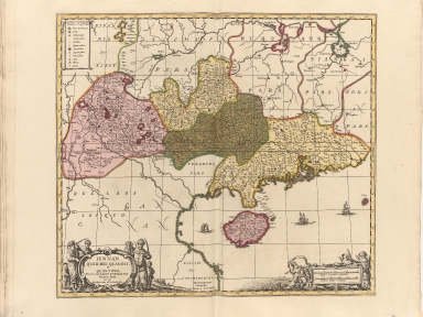
This map was published in the Latin version in four volumes of the 'Atlas minor sive Geographia compendiosa'. The map depicts the Southern China covering Hainan -under the administration of the Guangdong province from the 15th through 19th centuries- and the Pearl River Delta with Macao and the islands around Hong Kong.
|
|
Note:
|
Original is a copperplate printed map, water colored by hand published in the 'Atlas minor sive Geographia compendiosa in qua orbis terrarum Pavcis attamen Novissimis Tabulis ostenditur', 44 x 51 cm.
|
|
Note:
|
There are three sail ships depicted on the map.
|
|
Note:
|
Title in ornamented cartouche on the bottom left corner of the map with Chinese men and children on each side. Legend table at the upper left identifies cities and towns of various sizes, forts, and mines for gold, silver and iron.
|
|
Note:
|
Double scale line in "Milliaria Germanica communia" and "Milliaria Gallica communia", inside cartouche on the bottom right side with cherubs
|
|
Note:
|
Relief shown pictorially.
|
|
Note:
|
The four borders of the map with latitude and longitude lines in black and white interchangeably. Also labelled with North, South, East and West in Latin Septentrio (Septentriones), Meridies, Occidens and Oriens respectively.
|
|
Note:
|
The four provinces Yunnan, Guizhou, Guangxi and Guangdong colored in different colors with other provinces outlines in different colors.
|
|
Note:
|
Map outlined in triple fillet.
|
|
Note:
|
Macao and its surroundings.
|
|
Reference:
|
Van der Krogt, P.C.J. Koeman's Atlantes Neerlandici, Vis 13
|
|
Reference:
|
Phillips, P.L. A list of geographical atlases in the Library of Congress, vol. 1, p. 260-261
|
|
Geographic Area:
|
China
|
|
Geographic Area:
|
Yunnan Sheng (China)
|
|
Geographic Area:
|
Guizhou Sheng (China)
|
|
Geographic Area:
|
Guangxi Zhuangzu Zizhiqu (China)
|
|
Geographic Area:
|
Guangdong Sheng (China)
|
|
Geographic Area:
|
Hainan Sheng (China)
|
|
Pub Title:
|
Atlas minor sive Geographia compendiosa in qua orbis terrarum Pavcis attamen Novissimis Tabulis ostenditur. Atlas nouveau, etc.
|
|
Pub Year:
|
[ca. 1695-1756]
|
|
Pub location:
|
Amsterdam
|
|
Provenance:
|
Harvard College Library
|
|
Provenance:
|
http://id.lib.harvard.edu/alma/990040071590203941/catalog
|
|
Provenance Call No.:
|
GEN MA 18.40.2 pf*
|
|
MUST holding:
|
https://must.primo.exlibrisgroup.com/permalink/853MUST_INST/reglfj/alma991000455619705076
|