Detail View: Old Maps Collection: Map of the province of Kuang Tung : from native and foreign authorities
|
Barcode:
|
4687820500328
|
|
Title:
|
Map of the province of Kuang Tung : from native and foreign authorities
|
|
Contributor:
|
Hirth, Friedrich, 1845-1927, cartographer
|
|
Contributor:
|
Petermann, August, 1822-1878, engraver
|
|
Contributor:
|
Peip, Christian, 1843-1922, engraver
|
|
Contributor:
|
Domann, Bruno, 1854-1920, engraver
|
|
Contributor:
|
Hellfarth, Carl, 1846-1918, printer
|
|
Contributor:
|
Justus Perthes (Firm : Gotha, Germany), publisher
|
|
Category:
|
General Maps
|
|
Type:
|
Printed
|
|
Language:
|
English
|
|
Create Year:
|
1872-1873
|
|
Format:
|
JPEG 12842 × 9835, 34.1MB
|
|
Scale:
|
1:2,600,000 (E 108°13ʹ00ʺ--E 117°19ʹ00ʺ/N 25°31ʹ00ʺ--N 18°01ʹ00ʺ)
|
|
Physical Map Dimension (cm):
|
36 x 48 cm, on sheet 52 x 78 cm
|
|
Note:
|
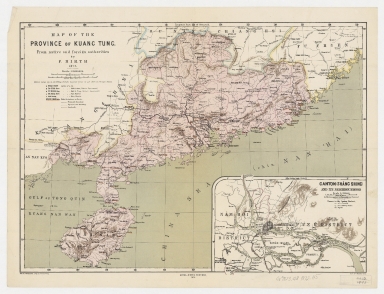
This is a detailed German map of Guangdong province in the second half of the 19th century with mountain ranges and river courses. The map also shows Hainan Island with significant detail. The inset on the lower right is a map of the surroundings of Canton city. The place names for the main map are given in the Mandarin and the ones on the inset accordingly to the Canton dialect.
|
|
Note:
|
Original is a copper plate printed map, 35 x 48 cm.
|
|
Note:
|
On the left bottom corner of the map: "Red. A. Petermann, autogr. by Domann & Peip."
|
|
Note:
|
Double scale line in Chinese Li and English miles underneath the title.
|
|
Note:
|
Relief shown by hachures.
|
|
Note:
|
Map with graticule.
|
|
Note:
|
The four borders of the map with latitude and longitude lines.
|
|
Note:
|
Map and inset outlined in double fillet.
|
|
Note:
|
Macao and its surroundings.
|
|
Geographic Area:
|
Guangdong Sheng (China)
|
|
Geographic Area:
|
Hainan Sheng (China)
|
|
Geographic Area:
|
Guangzhou Shi (China)
|
|
Provenance:
|
Harvard College Library
|
|
Provenance:
|
http://id.lib.harvard.edu/alma/990138226540203941/catalog
|
|
Provenance Call No.:
|
G7823.G8 1872 .H5
|
|
MUST holding:
|
https://must.primo.exlibrisgroup.com/permalink/853MUST_INST/171sgkf/alma991000435599705076
|