Detail View: Old Maps Collection: Rand McNally & Co.’s map of Asia and Europe
|
Barcode:
|
4687820500321
|
|
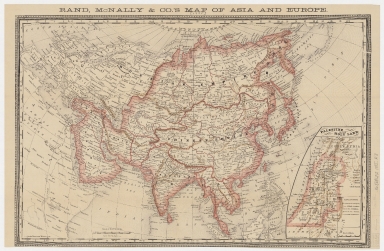
Title:
|
Rand McNally & Co.’s map of Asia and Europe
|
|
Original Title:
|
Rand McNally & Co.’s map of Asia and Europe
|
|
Contributor:
|
Rand McNally and Company
|
|
Category:
|
General Maps
|
|
Type:
|
Printed
|
|
Language:
|
English
|
|
Create Year:
|
1885
|
|
Format:
|
JPEG, 12624 × 8253, 34.8MB
|
|
Scale:
|
approximately 1:31,600,000
|
|
Physical Map Dimension (cm):
|
31 × 47
|
|
Note:
|
Relief shown by hachures. Prime meridian: Washington D.C. Includes inset: Palestine, or the Holy Land. Shows international borders.
|
|
Note:
|
Macao was marked in the middle of Pearl River Estuary in this map.
|
|
Geographic Area:
|
Asia
|
|
Geographic Area:
|
Europe
|
|
Pub Title:
|
Rand McNally & Co.’s map of Asia and Europe
|
|
Pub Author:
|
Rand McNally and Company
|
|
Pub Year:
|
[1885?]
|
|
Pub location:
|
Chicago
|
|
Provenance:
|
Harvard Map Collection - Harvard College Library
|