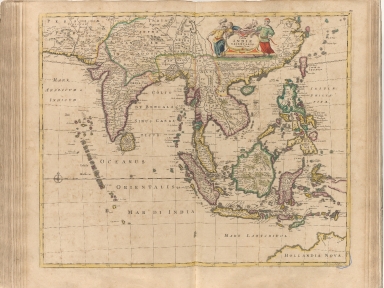
Detail View: Old Maps Collection: Tabula Indiae orientalis
|
Barcode:
|
4687820500318
|
|
Title:
|
Tabula Indiae orientalis
|
|
Original Title:
|
Tabula Indiae orientalis
|
|
Contributor:
|
Wit, Frederik de
|
|
Category:
|
General Maps
|
|
Type:
|
Printed
|
|
Language:
|
Latin
|
|
Create Year:
|
1662
|
|
Format:
|
JPEG, 10660 × 8000, 34.9MB
|
|
Scale:
|
[ca. 1:13,000,000]
|
|
Note:
|
Macao and the surrounding islands were depicted in this map.
|
|
Note:
|
Macao in East Indies Maps
|
|
Geographic Area:
|
Southeast Asia
|
|
Geographic Area:
|
India
|
|
Geographic Area:
|
Indonesia
|
|
Pub Title:
|
Atlas
|
|
Pub Author:
|
Wit, Frederik de
|
|
Pub Year:
|
[168-?]
|
|
Pub location:
|
Amsterdam
|
|
Provenance:
|
Harvard Map Collection - Harvard College Library
|