Detail View: Old Maps Collection: Map of the Typa and Macao
|
Barcode:
|
4687820500316
|
|
Title:
|
Map of the Typa and Macao
|
|
Original Title:
|
Sketch of the Typa and Macao
|
|
Contributor:
|
Bligh, Williams, 1754-1817
|
|
Contributor:
|
Harrison, William, about 1750-1803
|
|
Category:
|
Thematic Maps
|
|
Type:
|
Printed
|
|
Language:
|
English
|
|
Create Year:
|
1784 ca.
|
|
Format:
|
JPEG, 6188 × 7510, 42.3MB
|
|
Scale:
|
[ca. 1:70,684]
|
|
Physical Map Dimension (cm):
|
26 × 22
|
|
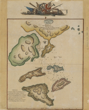
Note:
|
Text providing navigational directions entitled: References. "it was high water on the full and change of the moon at 5 h. 15 m in the Typa and at 5.50 in Macao Harbour, the greatest rise 6 feet"
|
|
Note:
|
This map was drawn according to information collected by the fleet of James Cook, a famous British navigator, explorer and cartographer, during his third Pacific cruise in 1780.The map details the hydrological data, waterways, backshores, water depth, latitudinal and longitudinal co-ordinates of Macao and its five neighbouring islands. It should be noted that“TYPA”is not Taipa today but the water way constituted by Taipa, Coloane and small Hengqin Island in Cross Gate water area. ; the waterway located at the southwest of the Macao Peninsula to Guangzhou was marked as ‘Macao Road’.
|
|
Note:
|
Macao and its Surroundings
|
|
Note:
|
City Plans of Macao
|
|
Subject:
|
Waterways
|
|
Geographic Area:
|
Macao (China)
|
|
Geographic Area:
|
Taipa Island (China)
|
|
Pub Title:
|
Sketch of the Typa and Macao
|
|
Pub Author:
|
Bligh, Williams, 1754-1817
|
|
Pub Author:
|
Harrison, William, about 1750-1803
|
|
Pub Year:
|
[178-]
|
|
Pub location:
|
[London]
|
|
Provenance:
|
Harvard Map Collection - Harvard College Library
|
|
MUST holding:
|
http://10.20.100.239/record=b1389971
|