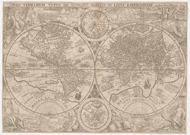
Detail View: Old Maps Collection: Orbis terrarum typus de integro multis in locis emendatus
|
Barcode:
|
4687820500314
|
|
Title:
|
Orbis terrarum typus de integro multis in locis emendatus
|
|
Original Title:
|
Orbis terrarvm typvs de integro multis in locis emendatus
|
|
Contributor:
|
Plancius, Petrus, 1552-1622
|
|
Category:
|
Hemispheres
|
|
Type:
|
Printed
|
|
Language:
|
Latin
|
|
Create Year:
|
1594
|
|
Format:
|
JPEG, 7112 × 5064, 44.7MB
|
|
Scale:
|
Scale not given
|
|
Physical Map Dimension (cm):
|
41 x 58
|
|
Note:
|
Double hemispherical map of the world, with 2 smaller celestial hemispheres. New Guinea shown as part of southern continent called Magallanica. The two hemispheres are surrounded by representations of Europa, Asia, Mexicana, Peruana, Africa, and Magallanica.
|
|
Note:
|
This is an early old map depicted the world and the East Asia before the Portuguese established the permanent settlement in Macao
|
|
Note:
|
Macao in World Maps
|
|
Geographic Area:
|
World
|
|
Pub Title:
|
Orbis terrarum typus de integro multis ...
|
|
Pub Author:
|
Plancius, Petrus, 1552-1622
|
|
Pub Year:
|
1594
|
|
Pub location:
|
[Netherlands?]
|
|
Provenance:
|
Houghton Library - Harvard College Library
|
|
MUST holding:
|
http://10.20.100.239/record=b1388976
|