Detail View: Old Maps Collection: Kanton
|
Barcode:
|
4687820500311
|
|
Title:
|
Kanton
|
|
Contributor:
|
Wolfgang, Abraham, fl. 1658-1694, printer
|
|
Contributor:
|
Janssonius van Waesberghe, Gillis, fl. 1675-1706, printer
|
|
Contributor:
|
Boom, Hendrick, 1644-1709, printer
|
|
Contributor:
|
Van Someren, Abraham, 1662-1700, printer
|
|
Contributor:
|
Goethals, Rembertus, fl. 1687-1706, printer
|
|
Category:
|
City Plans & Views
|
|
Type:
|
Printed
|
|
Language:
|
Dutch
|
|
Create Year:
|
1693
|
|
Format:
|
JPEG, 7831 × 5994, 51.9MB
|
|
Page No.:
|
4
|
|
Scale:
|
Scale not given.
|
|
Physical Map Dimension (cm):
|
21 x 33 cm, on sheet 31 x 40 cm
|
|
Note:
|
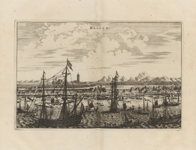
This a plan of the city of Guangzhou with its ramparts. It was published in the work 'Het gezantschap der Neêrlandtsche Oost-Indische Compagnie' of 1693 by Johannes Nieuhof. This book served as a major influence in the rise of popularity of the Orient in the early 18th century Europe. There are many boats depicted two of which are war ships. However, most of the vessels are for trade -ships and junks- denoting the importance of the city as one of the first treaty ports. At the center it can be seen a tall pagoda.
|
|
Note:
|
The original bird's eye view was published in the 'Het gezantschap der Neêrlandtsche Oost-Indische Compagnie, aan den grooten Tartarischen Cham, den tegenwoordigen keizer van China' by Johannes Nieuhof, 18 x 29 cm.
|
|
Note:
|
Relief shown pictorially.
|
|
Note:
|
View outlined in simple fillet.
|
|
Subject:
|
Nederlandsche Oost-Indische Compagnie
|
|
Geographic Area:
|
Guangzhou Shi (China)
|
|
Relation Note:
|
Pl. [4]
|
|
Pub Title:
|
Het gezantschap der Neêrlandtsche Oost-Indische Compagnie, aan den grooten Tartarischen Cham, den tegenwoordigen keizer van China
|
|
Pub Author:
|
Nieuhof, Johannes, 1618-1672
|
|
Pub Year:
|
1693
|
|
Pub location:
|
Amsterdam
|
|
Provenance:
|
Harvard College Library
|
|
Provenance:
|
http://id.lib.harvard.edu/alma/99153863511103941/catalog
|
|
Provenance Call No.:
|
GEN MA 17.71 (China) f*
|
|
MUST holding:
|
https://must.primo.exlibrisgroup.com/permalink/853MUST_INST/reglfj/alma991000042189705076
|