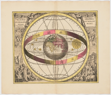
Detail View: Old Maps Collection: Scenographia systematis mvndani ptolemaici
|
Barcode:
|
4687820500309
|
|
Title:
|
Scenographia systematis mvndani ptolemaici
|
|
Original Title:
|
Scenographia systematis mvndani ptolemaici
|
|
Contributor:
|
Valck, G. (Gerard), 1651 or 1652-1726
|
|
Contributor:
|
Schenk, Peter, 1660-1718 or 1719
|
|
Category:
|
Thematic Maps
|
|
Type:
|
Printed
|
|
Language:
|
Latin
|
|
Create Year:
|
1708?
|
|
Format:
|
JPEG, 7694 × 6581, 50.4MB
|
|
Scale:
|
Scale not given
|
|
Note:
|
All maps engraved and hand-colored. Maps depict planispheres according to Ptolemy, Copernicus and Tycho Brahe; moon phases, constellations according to pagans and Christians, etc. Chart showing signs of the zodiac and the solar system with world at centre. Chart may be attributed to Andreas Cellarius. One of 29 double-folio plates digitized from Andreas Cellarius' Harmonia Macrocosmica. The second edition was published in 1661 and is a celestial atlas of the Ptolomaic, Copernican, and Tychonic world systems.
|
|
Note:
|
This is an early old map depicted the world and the East Asia before the Portuguese established the permanent settlement in Macao
|
|
Note:
|
Macao in World Maps
|
|
Subject:
|
Planispheres
|
|
Subject:
|
Constellations
|
|
Subject:
|
Astronomy
|
|
Subject:
|
Astrology
|
|
Geographic Area:
|
World
|
|
Pub Title:
|
Harmonia macrocosmica, seu, Atlas universalis et novus : totius universi creati cosmographiam generalem et novam exhibens : in quâ omnium totius mundi orbium harmonica constructio, secundum diversas diversorum authorum opiniones, ut & Vranometria, seu totus orbis cœlestis, ac planetarum theoriæ, & terrestris globus, tam planis & scenographicis iconibus, quam descriptionibus novis ab oculos ponuntur : opus novum, antehac nunquam visum, cujuscunque conditionis hominibus utilissimum, jucundissimum, maxime necessarium, & adornatum
|
|
Pub Author:
|
Cellarius, Andreas
|
|
Pub Year:
|
1708
|
|
Pub location:
|
Amsterdam
|
|
Provenance:
|
Houghton Library - Harvard College Library
|