Detail View: Old Maps Collection: Carte reduite du globe terrestre
|
Barcode:
|
4687820500305
|
|
Title:
|
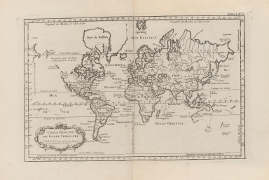
Carte reduite du globe terrestre
|
|
Original Title:
|
Carte reduite du globe terrestre
|
|
Contributor:
|
Bellin, Jacques Nicolas, 1703-1772
|
|
Category:
|
General Maps
|
|
Type:
|
Printed
|
|
Language:
|
French
|
|
Create Year:
|
1764
|
|
Format:
|
JPEG, 8622 × 5896, 54.9MB
|
|
Scale:
|
ca. 1:140 000 000
|
|
Note:
|
"L'Echelle de lieues pour mesurer les distances est au cote gauche de la carte." In upper right border: " In upper right corner: Tome I, No. 1.
|
|
Note:
|
This is an early old map depicted the world.The map was drawn by Jacques Nicolas Bellin who was the French naval hydrologist and chief cartographer.
|
|
Geographic Area:
|
World
|
|
Pub Title:
|
Le petit atlas maritime ; recueil de cartes et plans des quatre parties du monde
|
|
Pub Author:
|
Bellin, Jacques Nicolas, 1703-1772
|
|
Pub Year:
|
1764
|
|
Pub location:
|
Paris
|
|
Provenance:
|
Harvard Map Collection - Harvard College Library
|