Detail View: Old Maps Collection: Plan de la ville et du port de Macao = Grondtékening der stad en haven van Makao
|
Barcode:
|
4687820500047
|
|
Title:
|
Plan de la ville et du port de Macao = Grondtékening der stad en haven van Makao
|
|
Original Title:
|
Plan de la ville et du port de Macao = Grondtékening der stad en haven van Makao
|
|
Contributor:
|
Bellin, Jacques Nicolas, 1703-1772
|
|
Contributor:
|
Hondt, Pieter de
|
|
Contributor:
|
Schley, Jacobus van der, 1715-1779
|
|
Category:
|
Sea Charts
|
|
Type:
|
Printed
|
|
Language:
|
French
|
|
Language:
|
Dutch
|
|
Create Year:
|
1749
|
|
Format:
|
JPEG, 5259 × 6732, 32.9MB
|
|
Scale:
|
ca. 1:51,121
|
|
Physical Map Dimension (cm):
|
21 x 17
|
|
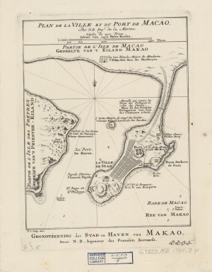
Note:
|
The lotus-stem-like contacting Macao and the land was drawn with the Border Gate Checkpoint, and the side note reads: ‘City wall separated the territories of Portugal and China’; the garrison city in the north was called the Qianshanzhai, and Qingzhou Island on the west was noted as the residence of Jesuits.
|
|
Note:
|
The map was drawn by Jacques Nicolas Bellin who was the French naval hydrologist and chief cartographer.
|
|
Note:
|
City Plans of Macao
|
|
Note:
|
Macao and its Surroundings
|
|
Subject:
|
Harbors
|
|
Geographic Area:
|
Macao (China)
|
|
Relation Note:
|
Appears in: Antoine François Prévost "L’Histoire générale des voyages". Hague : Pierre de Hondt, 1747-1767. 21 vols. (v.7, p. 9)
|
|
Pub Title:
|
L’Histoire générale des voyages
|
|
Pub Author:
|
Prévost, abbé, 1697-1763
|
|
Pub Year:
|
[1749]
|
|
Pub location:
|
[Hague]
|
|
Provenance:
|
Harvard Map Collection - Harvard College Library
|
|
MUST holding:
|
http://10.20.100.239/record=b1388940
|