Detail View: Old Maps Collection: Plan of the harbour of Nangasaky in Japan : from an ancient MS communicated in 1762
|
Barcode:
|
4687820500303
|
|
Title:
|
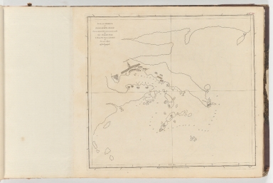
Plan of the harbour of Nangasaky in Japan : from an ancient MS communicated in 1762
|
|
Original Title:
|
Plan of the harbour of Nangasaky in Japan : from an ancient MS communicated in 1762
|
|
Contributor:
|
Hume, Alexande
|
|
Category:
|
Thematic Maps
|
|
Type:
|
Printed
|
|
Language:
|
English
|
|
Create Year:
|
1788
|
|
Format:
|
JPEG, 9063 × 6064, 55.5MB
|
|
Scale:
|
Scale not given
|
|
Note:
|
Map of Nangasaky harbour showing buildings, anchorages, and depth by soundings. Situation date: 1762. Oriented with north to the left.
|
|
Subject:
|
Harbors
|
|
Geographic Area:
|
Nagasaki-ken (Japan)
|
|
Pub Title:
|
Collection of plans of ports in the East Indies, etc. Vol. 2
|
|
Pub Author:
|
Dalrymple, Alexander, 1737-1808
|
|
Pub Year:
|
1774-91
|
|
Pub location:
|
[London]
|
|
Provenance:
|
Harvard Map Collection - Harvard College Library
|