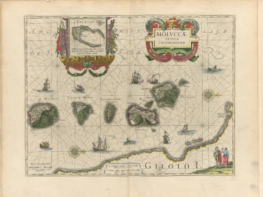
Detail View: Old Maps Collection: Moluccae insulae celeberrimae
|
Barcode:
|
4687820500267
|
|
Title:
|
Moluccae insulae celeberrimae
|
|
Original Title:
|
Molvccae insvlae celeberrimae
|
|
Contributor:
|
Blaeu, Willem Janszoon, 1571-1638
|
|
Contributor:
|
Hondius, Jodocus, 1594 or 1595-1629
|
|
Category:
|
Sea Charts
|
|
Type:
|
Printed
|
|
Language:
|
Latin
|
|
Create Year:
|
1630?
|
|
Format:
|
JPEG, 10660 × 8000, 32.1MB
|
|
Scale:
|
[ca. 1:260 000]
|
|
Physical Map Dimension (cm):
|
56 x 74
|
|
Note:
|
Inset : Bachian Island, in elaborate cartouche. Title in scrolled cartouche; figures in lower right hand corner. Topographical map of Molucca Islands of Motir, Macchian, Potterbackers, Tidoro, Ternate and Gilolo (Halmahera) with smaller islands. Relief and vegetation shown pictorially, including forts and factories.
|
|
Subject:
|
Nautical charts
|
|
Geographic Area:
|
Maluku (Indonesia)
|
|
Geographic Area:
|
Halmahera (Indonesia)
|
|
Geographic Area:
|
Ternate (Indonesia)
|
|
Geographic Area:
|
Tidore Island (Indonesia)
|
|
Pub Title:
|
Novus atlas, das ist, Weltbeschreibung, an den tag gegeben durch Guil. und Iohannem Blaeu
|
|
Pub Author:
|
Blaeu, Willem Janszoon, 1571-1638
|
|
Pub Year:
|
1649
|
|
Pub location:
|
Amsterdam
|
|
Provenance:
|
Harvard Map Collection - Harvard College Library
|
|
MUST holding:
|
http://10.20.100.239/record=b1388980
|