Detail View: Old Maps Collection: Empire of Japan
|
Barcode:
|
4687820500298
|
|
Title:
|
Empire of Japan
|
|
Other Title:
|
Nagasaki Harbour.
|
|
Other Title:
|
Eastern Point of Yeso.
|
|
Contributor:
|
Society for the Diffusion of Useful Knowledge (Great Britain), author
|
|
Contributor:
|
Kruzenshtern, Ivan Fedorovich, 1770-1846, bibliographic antecedent
|
|
Contributor:
|
Kaempfer, Engelbert, 1651-1716, bibliographic antecedent
|
|
Contributor:
|
J. & C. Walker (Firm), fl. 1820-1895, engraver
|
|
Contributor:
|
George Cox (Firm), publisher
|
|
Category:
|
General Maps
|
|
Type:
|
Printed
|
|
Language:
|
English
|
|
Create Year:
|
1853
|
|
Format:
|
JPEG 8950 × 10700, 25.4MB
|
|
Scale:
|
[ca. 1:2,200,000] (E 128°21ʹ00ʺ--E 143°51ʹ00ʺ/N 45°36ʹ00ʺ--N 30°16ʹ00ʺ).
|
|
Physical Map Dimension (cm):
|
39 x 31 cm, on sheet 48 x 40 cm
|
|
Note:
|
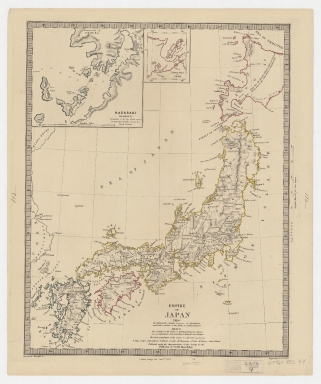
This map depicts Japan, the Strait of Korea and part of the east coast of Korea. Honshu, outlined in yellow, takes the center of the map, Kyushu and Shikoku are colored blue and magenta respectively. Yezo, present day Hokkaido, is also colored magenta and the northeastern part of the island is out of the map and so was integrated on inset 2. There is also an inset of the harbor of Nagasaki with a legend on the number of inhabitants and the location of the Dutch Factory on the island of Dejima (Desima). Underneath the title of the main map there is a legend on the cities and number of inhabitants of the two capitals of Japan, Kyoto (Meaco) and Tokyo (Yedo).
|
|
Note:
|
Inset 1: Nagasaki Harbour. - Scale indeterminable. - 12 x 13 cm. -- Inset 2: Eastern Point of Yeso. - Scale not given. - 6 x 5 cm.
|
|
Note:
|
Original is a copperplate printed map colored by hand, 38 x 30 cm.
|
|
Note:
|
On the bottom left corner of the map: "Krusenstern, Kaempfer & c." And on the bottom right: "Engraved by J. & C. Walker"
|
|
Note:
|
Scale line of the map and inset in English miles. Scale of the map on the right border of the map and scale of inset 1 underneath its title.
|
|
Note:
|
Relief shown by hachures and bathymetric relief by soundings.
|
|
Note:
|
Map and inset 2 with graticule.
|
|
Note:
|
Different islands outlined in different colors.
|
|
Note:
|
Map and insets outlined in triple fillet with piano keyboard border.
|
|
Subject:
|
Harbors
|
|
Geographic Area:
|
Japan
|
|
Geographic Area:
|
Nagasaki-ken (Japan)
|
|
Geographic Area:
|
Sea of Japan
|
|
Geographic Area:
|
Korea Strait
|
|
Provenance:
|
Harvard Map Collection
|
|
Provenance:
|
http://id.lib.harvard.edu/alma/990138615330203941/catalog
|
|
Provenance Call No.:
|
G7960 1853 .G4.
|
|
MUST holding:
|
https://must.primo.exlibrisgroup.com/permalink/853MUST_INST/171sgkf/alma991002990749005076
|