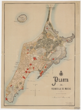
Detail View: Old Maps Collection: Planta da Peninsula de Macau

|
Barcode:
|
4687820500048
|
|
Title:
|
Planta da Peninsula de Macau
|
|
Contributor:
|
Heitor, António, fl. ca. 188--ca. 189-
|
|
Contributor:
|
Sociedade de Geografia de Lisboa
|
|
Category:
|
Thematic Maps
|
|
Type:
|
Printed
|
|
Language:
|
Portuguese
|
|
Create Year:
|
1889
|
|
Format:
|
JPEG, 15329 × 20718, 89.5MB
|
|
Scale:
|
Scale 1:5000.
|
|
Physical Map Dimension (cm):
|
77 x 50 cm, on sheet 113 x 72 cm
|
|
Note:
|
Plan of Macau in the late 19th century with stylized built-up typical of a plan. The major civil, religious and military buildings are colored red; however others are also identified such as pagodas, cemeteries, churches, hospitals, gardens and beaches. The built environment is in the south of the small peninsula, while the north-east corner is still cultivated. All streets and lanes are shown and most are named. The north-east corner of the island was untouched at this point with the Green Island present with the cement factory identified.
|
|
Note:
|
Original is a colored lithograph, 81 x 57 cm.
|
|
Note:
|
On the left bottom corner of the map: "Assumpção, lith.". And on the right bottom corner: "Lithographia da Imprensa Nacional."
|
|
Note:
|
Insignia of the Sociedade de Geografia de Lisboa above the title.
|
|
Note:
|
A 4-point compass rose with an arrow indicating north. Some scroll work elements decorate the title.
|
|
Note:
|
Relief shown pictorially, by form lines, spot heights and rock drawings.
|
|
Note:
|
Map outlined in double fillet.
|
|
Note:
|
City Plans of Macao.
|
|
Subject:
|
Land use
|
|
Subject:
|
City planning
|
|
Geographic Area:
|
Macao (China)
|
|
Provenance:
|
Harvard College Library
|
|
Provenance:
|
http://id.lib.harvard.edu/alma/990125720840203941/catalog
|
|
Provenance Call No.:
|
G7823.M2 1889 .H4
|
|
MUST holding:
|
https://must-primo.exlibris.com.cn/permalink/853MUST_INST/171sgkf/alma991000435439705076
|