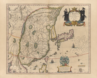
Detail View: Old Maps Collection: China veteribus sinarum regio nunc incolis tame dicta
|
Barcode:
|
4687820500295
|
|
Title:
|
China veteribus sinarum regio nunc incolis tame dicta
|
|
Original Title:
|
China veteribus sinarvm regio nunc incolis tame dicta
|
|
Contributor:
|
Blaeu, Joan, 1596-1673
|
|
Category:
|
General Maps
|
|
Type:
|
Printed
|
|
Language:
|
Latin
|
|
Create Year:
|
1635
|
|
Format:
|
JPEG, 10458 × 8000, 31MB
|
|
Scale:
|
Scale ca. 1 cm. to 7 German Miles; (E 85°--E 145°/N 53°--N 13°)
|
|
Note:
|
Possibly the work of Willem Blaeu or Jan Jansson. Decorated title cartouche with 2 figures. Includes illustrations of two masted vessels and sea creature. Copper engraving, printed on chain-lined paper with watermark. Sea of Korea not labeled; Korea represented as an island.
|
|
Note:
|
Macao and the surrounding islands were depicted in this map.
|
|
Geographic Area:
|
China
|
|
Geographic Area:
|
Japan
|
|
Geographic Area:
|
Korea
|
|
Pub Title:
|
Toonneel des aerdriicx, ofte nievwe atlas, dat is beschryving van alle landen
|
|
Pub Author:
|
Blaeu, Willem Janszoon, 1571-1638
|
|
Pub Year:
|
1635
|
|
Pub location:
|
Amsterdam
|
|
Provenance:
|
Harvard Map Collection - Harvard College Library
|