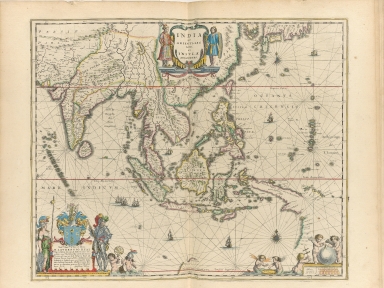
Detail View: Old Maps Collection: India quae Orientalis dicitur, et insulae adiacentes
|
Barcode:
|
4687820500287
|
|
Title:
|
India quae Orientalis dicitur, et insulae adiacentes
|
|
Original Title:
|
India quae Orientalis dicitur, et insvlae adiacentes
|
|
Contributor:
|
Blaeu, Willem Janszoon, 1571-1638
|
|
Category:
|
Sea Charts
|
|
Type:
|
Printed
|
|
Language:
|
Latin
|
|
Create Year:
|
1635
|
|
Format:
|
JPEG, 10660 × 8000, 31.9MB
|
|
Scale:
|
[ca. 1:17,700,000]
|
|
Note:
|
Map of south and southeast Asia. Northern coast line of New Guinea, southern coast line of Japan and tip of northern Australia is shown. Relief is shown pictorially for New Guinea. Scale in Milliaria Germanica.
|
|
Note:
|
Macao and the surrounding islands were depicted in this map.
|
|
Subject:
|
Nautical charts
|
|
Geographic Area:
|
Southeast Asia
|
|
Geographic Area:
|
South Asia
|
|
Pub Title:
|
Novus atlas, das ist, Weltbeschreibung, an den tag gegeben durch Guil. und Iohannem Blaeu
|
|
Pub Author:
|
Blaeu, Willem Janszoon, 1571-1638
|
|
Pub Year:
|
1649
|
|
Pub location:
|
Amsterdam
|
|
Provenance:
|
Harvard Map Collection - Harvard College Library
|