Detail View: Old Maps Collection: A new and accurate map of the Empire of Japan : laid down from the memoirs of the Portuguese and Dutch, and particularly from the Jesuit missionaries, as publish'd by the Sr. Bellin at Paris, being adjusted by astronomical observat.ns
|
Barcode:
|
4687820500284
|
|
Title:
|
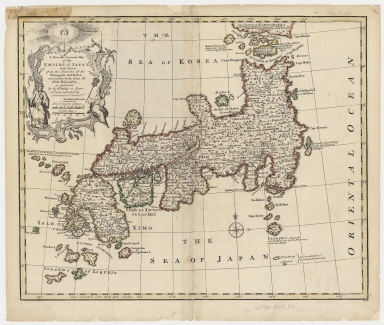
A new and accurate map of the Empire of Japan : laid down from the memoirs of the Portuguese and Dutch, and particularly from the Jesuit missionaries, as publish'd by the Sr. Bellin at Paris, being adjusted by astronomical observat.ns
|
|
Contributor:
|
Bowen, Emanuel, ca. 1693-1767, engraver
|
|
Category:
|
General Maps
|
|
Type:
|
Printed
|
|
Language:
|
English
|
|
Create Year:
|
[1747]
|
|
Format:
|
JPEG 11300 × 9575, 30.4MB
|
|
Scale:
|
[ca. 1:4,600,000] (E 130⁰--E 148⁰/N 42⁰--N 30⁰).
|
|
Physical Map Dimension (cm):
|
35 x 43 cm, on sheet 43 x 53 cm
|
|
Note:
|
Emanuel Bowen was a British engraver and print seller most well-known for his atlases and county maps. He was widely acknowledged for his expertise and was appointed as mapmaker to both George II of England and Louis XV of France. This map of Japan as stated in the title, owes much to that created by Jacques Nicolas Bellin (1703-1772) for he even copied Bellin's elaborate cartouche, only adjusting the longitude coordinates. The map also extends a bit further south than Bellin's, to include two 'Islands of Liqueio' and another two small islands south of 'Fatsisio I' named 'St. Anthony' and 'S. Roch I.', with a note that they were 'Discovered by the S.r Frandat in the year 1709'. The interior of the archipelago is described in great detail, where are identified Provinces, towns, islands, lakes and mountains. Several legends note the recently discovered islands, colonial details, etc.
|
|
Note:
|
Original is a printed map watercolored by hand, 34 x 42 cm.
|
|
Note:
|
Decorative title cartouche on the left upper corner of the map sided by a representation of a Japanese man and women, headed by a halo head. There is an 8-point compass rose on the map with a fleur de lis indicating north.
|
|
Note:
|
Double scale line in Japanese and English miles underneath the title.
|
|
Note:
|
Relief shown pictorially.
|
|
Note:
|
Different administrative regions outlined in different colors.
|
|
Note:
|
Map with graticule.
|
|
Note:
|
The four borders of the map with latitude and longitude lines.
|
|
Note:
|
Map outlined in simple bold fillet.
|
|
Reference:
|
Cortazzi, H. Isles of Gold, 81
|
|
Geographic Area:
|
Japan
|
|
Geographic Area:
|
Sea of Japan
|
|
Geographic Area:
|
Sea of Korea
|
|
Provenance:
|
Harvard Map Collection
|
|
Provenance:
|
http://id.lib.harvard.edu/alma/990125797870203941/catalog
|
|
Provenance Call No.:
|
G7960 1747 .B6
|
|
MUST holding:
|
https://must.primo.exlibrisgroup.com/permalink/853MUST_INST/171sgkf/alma991002990749205076
|