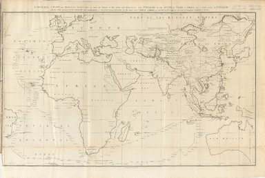
Detail View: Old Maps Collection: A general chart, on Mercator's projection, to shew the track of the Lion and Hindostan from England to the Gulph of Pekin in China, and of their return to England
|
Barcode:
|
4687820500262
|
|
Title:
|
A general chart, on Mercator's projection, to shew the track of the Lion and Hindostan from England to the Gulph of Pekin in China, and of their return to England
|
|
Original Title:
|
A general chart, on Mercator's projection, to shew the track of the Lion and Hindostan from England to the Gulph of Pekin in China, and of their return to England
|
|
Contributor:
|
Barrow, John
|
|
Category:
|
Thematic Maps
|
|
Type:
|
Printed
|
|
Language:
|
English
|
|
Create Year:
|
1796
|
|
Format:
|
JPEG, 11557 × 7768, 84.3MB
|
|
Scale:
|
[ca. 1:22 500 000]
|
|
Physical Map Dimension (cm):
|
25 x 41.3
|
|
Note:
|
Map of the Eastern hemisphere with relief shown pictorially.
|
|
Note:
|
Macao and the surrounding islands were depicted in this map.
|
|
Note:
|
Macao in World Maps
|
|
Note:
|
Macao in Routes
|
|
Subject:
|
Voyages and travels
|
|
Subject:
|
Discoveries in geography
|
|
Geographic Area:
|
Eastern Hemisphere
|
|
Pub Title:
|
An authentic account of an embassy from the King of Great Britain to the Emperor of China; including cursory observations made, and information obtained in travelling through that ancient empire, and a small part of Chinese Tartary.
|
|
Pub Author:
|
Staunton, George, Sir, 1737-1801
|
|
Pub Year:
|
1797
|
|
Pub location:
|
London
|
|
Provenance:
|
Harvard Map Collection - Harvard College Library
|
|
MUST holding:
|
http://10.20.100.239/mockbib
|