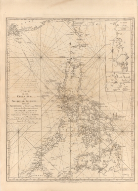
Detail View: Old Maps Collection: A chart of the China Sea, and Philippine Islands with the Archipelagos of Felicia and Soloo : shewing the whole tract comprized, between Canton and Balambangan, with the soundings, shoals, rocks, & ca.
|
Barcode:
|
4687820500260
|
|
Title:
|
A chart of the China Sea, and Philippine Islands with the Archipelagos of Felicia and Soloo : shewing the whole tract comprized, between Canton and Balambangan, with the soundings, shoals, rocks, & ca.
|
|
Other Title:
|
The Ports of Ylocos, on the West Coast of Luzon
|
|
Other Title:
|
The Bay of Subic, on the New Coast of Luzon
|
|
Contributor:
|
Whittle & Laurie, publisher
|
|
Category:
|
Sea Charts
|
|
Type:
|
Printed
|
|
Language:
|
English
|
|
Create Year:
|
1794
|
|
Format:
|
JPEG 10479 × 7635, 94.2MB
|
|
Scale:
|
Scale not given.
|
|
Physical Map Dimension (cm):
|
76 x 60 cm, on sheet 94 x 69 cm
|
|
Note:
|
This navigational chart focuses primarily on the various islands of the Philippines, but also includes north-end Borneo, a part of the South China coast and South Taiwan. On the map there also two insets of the Ports of Ylocos and the Bay of Subic, both on the Luzon Island. Some routes are given with the ships name and date of the travel. The track from Canton -Guangzhou- and Balambangan in December 1773 is given with position of the ship by day.
|
|
Note:
|
Inset 1: The Ports of Ylocos, on the West Coast of Luzon. - Scale indeterminable. - 24 x 12 cm. -- Inset 2: The Bay of Subic, on the New Coast of Luzon. - Scale indeterminable. - 9 x 12 cm.
|
|
Note:
|
Original is a copper printed map, 76 x 60 cm.
|
|
Note:
|
There are two vessels engaged in battle on the map with the legend stating that it is the Spanish Galeon Nostra Señora de Cabadonga [i.e. Covadonga] taken by the Centurion, with the date June the 20.th 1743.
|
|
Note:
|
Two fleur de lis indicating north on the main map. Two 8-point compass roses, one on each inset, with a fleur de lis indicating north.
|
|
Note:
|
Relief shown by pictorially. Bathymetric relief given by soundings.
|
|
Note:
|
Map with graticule.
|
|
Note:
|
The four borders of the map with latitude and longitude lines.
|
|
Note:
|
Map and insets outlined in double fillet.
|
|
Note:
|
Macao in East Indies Maps.
|
|
Note:
|
Macao in routes.
|
|
Subject:
|
Nautical charts
|
|
Geographic Area:
|
Philippines
|
|
Relation Note:
|
Vol. 2
|
|
Pub Title:
|
The Complete East-India Pilot, Or, Oriental Navigator: Being an Extensive Collection of Charts Both General and Particular with Plans of Bays, Roads and Harbours, Appearances of Land &c. &c. for the Navigation Not Only of the Indian and China Seas with Those of New Holland, But Also of the Seas Between the British Isles and the Cape of Good Hope
|
|
Pub Author:
|
Après de Mannevillette, Jean-Baptiste-Nicolas-Denis d', 1707-1780
|
|
Pub Year:
|
1800
|
|
Pub location:
|
London
|
|
Provenance:
|
Harvard College Library
|
|
Provenance:
|
http://id.lib.harvard.edu/alma/990039629980203941/catalog
|
|
Provenance Call No.:
|
G1781.P5 L3 1800 pf*
|
|
MUST holding:
|
https://must-primo.exlibris.com.cn/permalink/853MUST_INST/171sgkf/alma991002970348905076
|