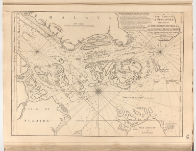
Detail View: Old Maps Collection: The Straits of Sincapore with those of Drion, Sabon, Mandol &ra and south part of Malacca Straits
|
Barcode:
|
4687820500259
|
|
Title:
|
The Straits of Sincapore with those of Drion, Sabon, Mandol &ra and south part of Malacca Straits
|
|
Original Title:
|
The Straits of Sincapore with those of Drion, Sabon, Mandol &ra and south part of Malacca Straits
|
|
Contributor:
|
Laurie & Whittle
|
|
Category:
|
Sea Charts
|
|
Type:
|
Printed
|
|
Language:
|
English
|
|
Create Year:
|
1799
|
|
Format:
|
JPEG, 6046 × 7848, 54.9MB
|
|
Scale:
|
Scale not given
|
|
Note:
|
Nautical map of the Straits of Singapore, Mandol, Sabon and Durion showing island names and depth by soundings and relief shown pictorially. "Improved and corrected from the observations of Captn. John Hall of the Worcester; Captn. J. Lindsey, Captn. Elmore and other navigators."
|
|
Subject:
|
Nautical charts
|
|
Geographic Area:
|
China Sea
|
|
Geographic Area:
|
Southeast Asia
|
|
Geographic Area:
|
Strait of Malacca
|
|
Geographic Area:
|
Singapore
|
|
Geographic Area:
|
Malay Archipelago
|
|
Pub Title:
|
The complete East-India pilot, or oriental navigator ... chiefly composed from actual surveys and draughts communicated by experienced officers of The East-India Company and from the French Neptune oriental
|
|
Pub Author:
|
Après de Mannevillette, Jean-Baptiste-Nicolas-Denis d’, 1707-1780
|
|
Pub Year:
|
1800
|
|
Pub location:
|
London
|
|
Provenance:
|
Harvard Map Collection - Harvard College Library
|