Detail View: Old Maps Collection: A chart of the China Sea from the Island of Sanciam to Pedra Branca with the course of the River Tigris from Canton to Macao
|
Barcode:
|
687800354127B
|
|
Title:
|
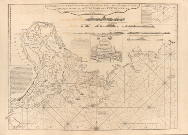
A chart of the China Sea from the Island of Sanciam to Pedra Branca with the course of the River Tigris from Canton to Macao
|
|
Other Title:
|
Plan of the Typa.
|
|
Other Title:
|
Appearance of Great Ladrone and Lema Islands.
|
|
Other Title:
|
Appearance of Lema Islands.
|
|
Other Title:
|
Appearance of the Gap Rock, the Westermost of the Rocks of Lema, when it bears W.N.W. a Mile & a half dist.e.
|
|
Other Title:
|
Plan of Quang Cheou Fou or Canton.
|
|
Contributor:
|
Après de Mannevillette, Jean-Baptiste-Nicolas-Denis d', 1707-1780, cartographer
|
|
Contributor:
|
Larkins, John Pascal, 17---1794, author, bibliographic antecedent
|
|
Contributor:
|
Anson, George Anson, baron, 1697-1762, author
|
|
Contributor:
|
Huddart, Joseph, 1741-1816, bibliographic antecedent
|
|
Category:
|
Sea Charts
|
|
Type:
|
Printed
|
|
Language:
|
English
|
|
Create Year:
|
1794
|
|
Format:
|
JPEG 10454 × 7552, 91.9MB
|
|
Scale:
|
Scale not given.
|
|
Physical Map Dimension (cm):
|
60 x 80 cm, on sheet 69 x 88 cm
|
|
Note:
|
This is a quite detailed nautical chart of the South China Sea extending from Shangchuan Island (S.t John's Island) to Honghai Bay (Brandon's Bay), with the islands of Macau and Hong Kong, separated by a channel. The map was originally issued by Sayer & Bennett, with the date of 29 November 1780, under the title 'A Chart of the China Sea from the Island of Sanciam To Pedra Branca with the Course of the River Tigris From Canton to Macao from a Portuguese draught communicated by Captain Hayter and compared with the Chinese Chart of the Macao Pilots'. This one, however, has been updated by Captains Joseph Huddart and John Pascal Larkins of the East India Company. Joseph Huddart was an important and influential English Captain, hydrographer, chart maker, inventor and entrepreneur. His first ship, the Patience, was designed and built by Huddart himself and launched in 1768 for the North American trade. In 1773, Huddart joined the East India Company, during the course of this voyage he made detailed scientific observations and surveys of the West coast of Sumatra. The extensive number of soundings along the coast line, surrounding islands and upriver to Guangzou (Canton) demonstrates both the navigational use of this map and the routes preferred by the English for trade in China. The chart includes coastal profiles of the islands of the Wanshan Archipelago; an inset of the Taipa (Typa) Anchorage and another one of the city of Guangzhou. On the left side of the map there is an extensive description by the Captain John Pascal Larkins with safe directions for the passage from Shangchuan to Macau. Most of the place names on the map are romanized versions of the Chinese names. The most notable feature of the map is the division of Hong Kong Island, separated by a channel, the shape of Lantao is badly distorted, especially on the eastern side.
|
|
Note:
|
Inset 1: Plan of the Typa / by Capt.n Baker. - Scale indeterminable. - 9 x 16 cm. -- Inset 2: Appearance of Great Ladrone and Lema Islands / (from the English Pilot). - Scale not given. - 5 x 35 cm. -- Inset 3: Appearance of Lema Islands / (from Admiral Anson.). - Scale not given. - 1 x 47 cm. -- Inset 4: Appearance of the Gap Rock, the Westermost of the Rocks of Lema, when it bears W.N.W. a Mile & a half dist.e / (From Admiral Anson.). - Scale not given. - 1 x 17 cm. -- Inset 5: Plan of Quang Cheou Fou or Canton. - Scale indeterminable. - 13 x 15 cm.
|
|
Note:
|
Original is a copperplate print map from vol. 2 of the work 'The complete East-India pilot, or oriental navigator' by Jean-Baptiste Mannevillette.
|
|
Note:
|
There is a half 32-point compass rose on the bottom part of the map, with a fleur-de-lis indicating north on the main map. Inset 1 and 5 have a fleur-de-lis indicating north, the latter with an arrow indicating the east point.
|
|
Note:
|
Relief shown pictorially and by land forms, bathymetric relief by soundings on the main map. Inset 1 with only bathymetric relief by soundings and inset 5 with bathymetric relief by isolines.
|
|
Note:
|
Latitude lines on both sides of the map in black and white interchangeably.
|
|
Note:
|
Main map and insets 1 and 5outlined in double fillet.
|
|
Note:
|
Macao and its surroundings.
|
|
Subject:
|
Nautical charts
|
|
Geographic Area:
|
Macao (China)
|
|
Geographic Area:
|
Hong Kong (China)
|
|
Geographic Area:
|
Guangzhou Shi (China)
|
|
Geographic Area:
|
Islands of the South China Sea
|
|
Geographic Area:
|
South China Sea
|
|
Relation Note:
|
Vol. 2
|
|
Pub Title:
|
Complete East-India pilot, or oriental navigator
|
|
Pub Author:
|
Après de Mannevillette, Jean-Baptiste-Nicolas-Denis d', 1707-1780
|
|
Pub Year:
|
1800
|
|
Pub location:
|
London
|
|
Provenance:
|
Harvard College Library
|
|
Provenance:
|
http://id.lib.harvard.edu/alma/990039629980203941/catalog
|
|
Provenance Call No.:
|
G1781.P5 L3 1800 pf*
|
|
MUST holding:
|
https://must.primo.exlibrisgroup.com/permalink/853MUST_INST/171sgkf/alma991002923849005076
|