Detail View: Old Maps Collection: A chart of the Straits of Malacca and Sincapore
|
Barcode:
|
4687820500256
|
|
Title:
|
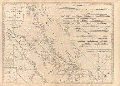
A chart of the Straits of Malacca and Sincapore
|
|
Original Title:
|
A chart of the Straits of Malacca and Sincapore
|
|
Contributor:
|
Thomas, Jeffrey
|
|
Category:
|
Sea Charts
|
|
Type:
|
Printed
|
|
Language:
|
English
|
|
Create Year:
|
1794
|
|
Format:
|
JPEG, 10609 × 7642, 93.5MB
|
|
Scale:
|
[ca. 1:94.260]
|
|
Note:
|
Nautical map of the Straits of Malucca and Singapore, showing place names, shoals, depth shown by soundings and relief shown by hachures.; Includes 23 views of coastal profiles to aid navigation. Inset: A Plan of the road of Achen with the several passages between the adjacent islands. "Observations by Mr. Sampfon Hall in 1784"
|
|
Subject:
|
Nautical charts
|
|
Geographic Area:
|
Strait of Malacca
|
|
Geographic Area:
|
Singapore
|
|
Geographic Area:
|
Malay Archipelago
|
|
Pub Title:
|
The complete East-India pilot, or oriental navigator ... chiefly composed from actual surveys and draughts communicated by experienced officers of The East-India Company and from the French Neptune oriental
|
|
Pub Author:
|
Après de Mannevillette, Jean-Baptiste-Nicolas-Denis d’, 1707-1780
|
|
Pub Year:
|
1800
|
|
Pub location:
|
London
|
|
Provenance:
|
Harvard Map Collection - Harvard College Library
|