Detail View: Old Maps Collection: A chart of the south coast of Hay-nan, from Tinhosa to Guichou
|
Barcode:
|
4687820500255
|
|
Title:
|
A chart of the south coast of Hay-nan, from Tinhosa to Guichou
|
|
Contributor:
|
Haldane, John, captain, fl. 177-, cartographer
|
|
Contributor:
|
Laurie & Whittle, publisher
|
|
Category:
|
Sea Charts
|
|
Type:
|
Printed
|
|
Language:
|
English
|
|
Language:
|
Portuguese
|
|
Create Year:
|
1794
|
|
Format:
|
JPEG 10613 × 7512, 84MB
|
|
Page No.:
|
72
|
|
Scale:
|
Scale indeterminable.
|
|
Physical Map Dimension (cm):
|
33 x 73 cm, on sheet 45 x 92 cm
|
|
Note:
|
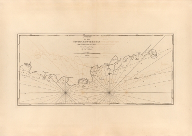
This is a large-format of a sea chart with focus on the south coast of Hainan, the great tropical island that lies off of China’s southernmost shores. It is based on the manuscript chart made by John Haldane, a mariner working for the British East India Company (EIC). The south coast of Hainan was long a popular stopover for European vessels on their way to and from the Strait of Malacca to Canton -Guangzhou. However, vessels tended to stay only briefly along the Hainan coast without making any attempt to map the island’s coastlines. In the autumn of 1776, the Earl of Sandwich, a vessel in the service of the EIC, commanded by Captain Charles Deane, endeavoured to make the voyage from India to Canton, but arrived too late in the season to take advantage of the seasonal conditions. Deane brought the Sandwich into Yalong Bay, deciding to remain there for most the winter until sailing conditions improved. The Master of the Sandwich, John Haldane had the occasion to survey the south coast of Hainan. Although Haldane’s work did not meet the standards of a scientific systematic survey, it marked a vast improvement over the contemporary European knowledge of the coast, being of a practically useful, general planimetric accuracy. Little is known of John Haldane, it seems that by the time that the present map was published, Haldane had been promoted to captain in the EIC service, so being identified with that rank on the map. From west to east, we start at the castellated ‘Guichou’ -today located at Gangmen Harbour- to ‘Samouy’ -Sanya, southern Hainan’s largest city- to ‘Galoon Bay’, or Yalong Bay, to the northeast, where is a fort labelled ‘Tonckeu’, at the site of Tengquiogang, on Tufu Bay; while further along is a fort labelled ‘Tongsoy’, which guards the mouth of the ‘Salt Water Lake’. Further east there is ‘Linksuey’ -Lingshui- and the island of ‘Tinhosa’ -Dazhou Island- an important navigational marker. All along the coastline, the waters feature copious bathymetric soundings.
|
|
Note:
|
Original is a copper printed map, 34 x 74 cm.
|
|
Note:
|
Scale line in sea leagues underneath the title.
|
|
Note:
|
Two 32-point compass roses, one with a fleur de lis indicating north. The rhumb lines for half winds in dotted line.
|
|
Note:
|
Relief shown by pictorially. Bathymetric relief given by soundings.
|
|
Note:
|
The four borders of the map with latitude and longitude lines.
|
|
Subject:
|
Nautical charts
|
|
Geographic Area:
|
Hainan Sheng (China)
|
|
Relation Note:
|
Vol. 2, [72]
|
|
Pub Title:
|
The Complete East-India Pilot, Or, Oriental Navigator: Being an Extensive Collection of Charts Both General and Particular with Plans of Bays, Roads and Harbours, Appearances of Land &c. &c. for the Navigation Not Only of the Indian and China Seas with Those of New Holland, But Also of the Seas Between the British Isles and the Cape of Good Hope.
|
|
Pub Author:
|
Après de Mannevillette, Jean-Baptiste-Nicolas-Denis d’, 1707-1780
|
|
Pub Year:
|
1800
|
|
Pub location:
|
London
|
|
Provenance:
|
Harvard College Library
|
|
Provenance:
|
http://id.lib.harvard.edu/alma/990039629980203941/catalog
|
|
Provenance Call No.:
|
G1781.P5 L3 1800 pf*
|
|
MUST holding:
|
https://must-primo.exlibris.com.cn/permalink/853MUST_INST/reglfj/alma991002974249605076
|