Detail View: Old Maps Collection: Plan of Galloon Bay on the Island of Hay-nan : where the ship Earl of Sandwich Cap.t Charles Deane winteres in 1776 and 77 having lost her passage to China
|
Barcode:
|
4687820500254
|
|
Title:
|
Plan of Galloon Bay on the Island of Hay-nan : where the ship Earl of Sandwich Cap.t Charles Deane winteres in 1776 and 77 having lost her passage to China
|
|
Contributor:
|
Haldane, John, captain, fl. 177-, cartographer
|
|
Contributor:
|
Whittle & Laurie, publisher
|
|
Category:
|
Thematic Maps
|
|
Type:
|
Printed
|
|
Language:
|
English
|
|
Create Year:
|
1794
|
|
Format:
|
JPEG 10510 × 7456, 84.5MB
|
|
Scale:
|
Scale not given.
|
|
Physical Map Dimension (cm):
|
45 x 64 cm, on sheet 61 x 79 cm
|
|
Note:
|
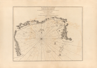
This sea chart depicts Yelong Bay or Galloon Bay on the southern coast of Hainan Island, China. The coast line is highly detailed and the surrounding islands are also depicted: 'Turtle Island' -Xizhou-, 'Rocky Island' -Dongzhou- and 'Middle Island' -Yeshudao. Depth soundings are noted throughout as are sand banks and other coastal features important for navigation. It is based on the manuscript chart made by John Haldane, a mariner working for the British East India Company (EIC). The south coast of Hainan was long a popular stopover for European vessels on their way to and from the Strait of Malacca to Canton -Guangzhou. However, vessels tended to stay only briefly along the Hainan coast without making any attempt to map the island’s coastlines. In the autumn of 1776, the Earl of Sandwich, a vessel in the service of the EIC, commanded by Captain Charles Deane, endeavoured to make the voyage from India to Canton, but arrived too late in the season to take advantage of the seasonal conditions. Deane brought the Sandwich into Yalong Bay, deciding to remain there for most the winter until sailing conditions improved. The Master of the Sandwich, John Haldane had the occasion to survey the south coast of Hainan. Although Haldane’s work did not meet the standards of a scientific systematic survey, it marked a vast improvement over the contemporary European knowledge of the coast, being of a practically useful, general planimetric accuracy. Little is known of John Haldane, it seems that by the time that the present map was published, Haldane had been promoted to captain in the EIC service, so being identified with that rank on the map.
|
|
Note:
|
Original is a copper printed map, 50 x 64 cm.
|
|
Note:
|
Illustrations of buildings adorn the coast and five vessels can be seen sailing in the waters. A 32-point compass roses in the middle with a fleur de lis indicating north. The rhumb lines for the half winds are dotted lines.
|
|
Note:
|
Scale line in one league or three miles underneath the title.
|
|
Note:
|
Relief shown by pictorially. Bathymetric relief given by soundings.
|
|
Note:
|
Map outlined in double fillet.
|
|
Geographic Area:
|
Hainan Sheng (China)
|
|
Relation Note:
|
Vol. 2
|
|
Pub Title:
|
The Complete East-India Pilot, Or, Oriental Navigator: Being an Extensive Collection of Charts Both General and Particular with Plans of Bays, Roads and Harbours, Appearances of Land &c. &c. for the Navigation Not Only of the Indian and China Seas with Those of New Holland, But Also of the Seas Between the British Isles and the Cape of Good Hope
|
|
Pub Author:
|
Après de Mannevillette, Jean-Baptiste-Nicolas-Denis d’, 1707-1780
|
|
Pub Year:
|
1800
|
|
Pub location:
|
London
|
|
Provenance:
|
Harvard College Library
|
|
Provenance:
|
http://id.lib.harvard.edu/alma/990039629980203941/catalog
|
|
Provenance Call No.:
|
G1781.P5 L3 1800 pf*
|
|
MUST holding:
|
https://must-primo.exlibris.com.cn/permalink/853MUST_INST/reglfj/alma991002974249505076
|