Detail View: Old Maps Collection: A survey of the Tigris, from Canton to the Island of Lankeet : to William Henry Pigou Esq.r first supercargo for the Affairs of the Honourable East India Company
|
Barcode:
|
4687820500232
|
|
Title:
|
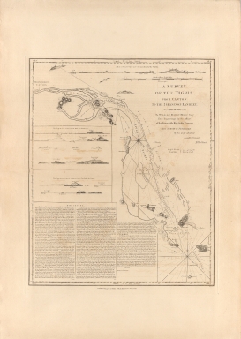
A survey of the Tigris, from Canton to the Island of Lankeet : to William Henry Pigou Esq.r first supercargo for the Affairs of the Honourable East India Company
|
|
Other Title:
|
A view of the land taken upon the lower shoal of the first bar.
|
|
Other Title:
|
Thus appears the land from X near the second bar.
|
|
Other Title:
|
Thus appears the land of the Bocca Tigris from below the Islands.
|
|
Contributor:
|
Huddart, Joseph, 1741-1816, hydragrapher
|
|
Contributor:
|
Pigou, William Henry, dedicatee
|
|
Contributor:
|
Whittle & Laurie, publisher
|
|
Category:
|
Thematic Maps
|
|
Type:
|
Printed
|
|
Language:
|
English
|
|
Create Year:
|
1794
|
|
Format:
|
JPEG 7576 × 10660, 91.1MB
|
|
Scale:
|
[ca 1:98,000]
|
|
Physical Map Dimension (cm):
|
60 x 49 cm, on sheet 77 x 61 cm
|
|
Note:
|
This is a detailed chart of the Chinese coastline from the city of Canton -Guangzhou- southwards to the Island of Lankeet. To the left of the survey are further depictions of parcels of land, as they appear from the sea. Below in three columns is a very detailed and lengthy set of maritime instructions as stipulated and set down by Joseph Huddart in 1786. The set of the survey, the legend and the side land views provide detailed sailing instructions and coasted profiles for navigating lower Chu River from Macau via the Bocca Tigris narrows below the Anunghoi Fort up to Whampoa, Dane's Island, and the foreign settlements of Guangzhou
|
|
Note:
|
Inset 1: A view of the land taken upon the lower shoal of the first bar. - 2 x 42 cm. -- Inset 2: Thus appears the land from X near the second bar. - 11 x 21 cm. -- Inset 3: Thus appears the land of the Bocca Tigris from below the Islands. - 8 x 21 cm.
|
|
Note:
|
Original is a copper printed map, 80 x 60 cm.
|
|
Note:
|
On the bottom right corner of the map: "Wigzell sc.t"
|
|
Note:
|
There are eight coastal profiles on the map for navigational aid. Two 32-point compass roses on the chart with a fleur de lis indicating north. The rhumb lines for the quarter winds are dotted lines.
|
|
Note:
|
Double scale line in leagues and English miles above the title.
|
|
Note:
|
Relief shown by pictorially, by hachures and by landforms. Bathymetric relief given by soundings.
|
|
Note:
|
The four borders of the map with latitude and longitude lines.
|
|
Note:
|
Prime meridian: Greenwich.
|
|
Note:
|
Map and insets outlined in double fillet.
|
|
Reference:
|
Van Dyke, P.A. Merchants of Canton and Macao: Success and Failure in Eighteenth-Century Chinese Trade, p. 392
|
|
Reference:
|
Hong Kong Maritime Museum. Charting the Pearl River Delta: a catalogue of charts, sailing directions, views and a bibliography pertaining to charting the Pearl River Delta, p. 11, 84
|
|
Subject:
|
River surveys
|
|
Geographic Area:
|
Pearl River (China)
|
|
Geographic Area:
|
Tigris River
|
|
Relation Note:
|
Vol. 2
|
|
Pub Title:
|
The Complete East-India Pilot, Or, Oriental Navigator: Being an Extensive Collection of Charts Both General and Particular with Plans of Bays, Roads and Harbours, Appearances of Land &c. &c. for the Navigation Not Only of the Indian and China Seas with Those of New Holland, But Also of the Seas Between the British Isles and the Cape of Good Hope
|
|
Pub Author:
|
Après de Mannevillette, Jean-Baptiste-Nicolas-Denis d', 1707-1780
|
|
Pub Year:
|
1800
|
|
Pub location:
|
London
|
|
Provenance:
|
Harvard College Library
|
|
Provenance:
|
http://id.lib.harvard.edu/alma/990039629980203941/catalog
|
|
Provenance Call No.:
|
G1781.P5 L3 1800 pf*
|
|
MUST holding:
|
https://must-primo.exlibris.com.cn/permalink/853MUST_INST/reglfj/alma991002982449805076
|