Detail View: Old Maps Collection: Plano del rio por el qual se navega con embarcaciones menores entre Macao y Canton
|
Barcode:
|
3687800371299K
|
|
Title:
|
Plano del rio por el qual se navega con embarcaciones menores entre Macao y Canton
|
|
Contributor:
|
Agote y Bonechea, Manuel de, 1755-1803.
|
|
Contributor:
|
Guignes, Joseph de, 1721-1800, dedicatee.
|
|
Category:
|
Navigational chart
|
|
Type:
|
Manuscript
|
|
Language:
|
Spanish
|
|
Create Year:
|
1792
|
|
Scale:
|
Scale not given.
|
|
Physical Map Dimension (cm):
|
60 x 38 cm, on sheet 61 x 39 cm
|
|
Note:
|
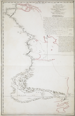
This is a plan made by the Spaniard Manuel de Agote y Bonechea, traveler and senior freight clerk of the Royal Philippine Company in Guangzhou between 1787 and 1796, which focuses on the Modao Men, west of Macao. Modao Men in the Xi Jiang, the western tributary of the Pearl River, was a standard commercial route for foreign ships to sail from Macao to Guangzhou (Canton). For many years, Chinese authorities exclusively allowed its use to the Portuguese, forcing other European nations to sail along the Lingding Yang, on the east, via Humen and Huangpu (Vampu). Although the plan displays a clear navigational purpose, on the extensive warning underneath the title, the author advises it is useless to try and navigate the area with the aid of this map alone as one must always appeal to Chinese sailors. Agote clarifies the red outline is taken from the 1786 map 'A survey of the Tigris, from Canton to the island of Lankeet' by Joseph Huddart (1741-1816), with him adding the parts in black. He started collecting information on the channel during all his trips to Guangzhou that, by the year of the creation of the plan, were already nine. He acknowledges the plan may not be the most precise, but he tried to correct previous mistakes, even if all measurements were made on board, as westerners were not allowed on land for long periods of time. In the map, Macao can be seen on the right bottom corner with Portas do Cerco and the outlines of the city and fortresses, as well as the blank islands of Ilha Verde (Chian-chau o Ysla Verde), Taipa Grande and Taipa Pequena, Coloane, Duimian Shan, Xiaohengqin and Dahengqin. The route from Macao to Guangzhou goes west and along the way are marked cities, villages, watch posts and pagodas, identified as towers, that could be used as localization points.
|
|
Note:
|
Original is a manuscript map, 62 x 39 cm.
|
|
Note:
|
There is a 4-point compass rose with a half fleur-de-lis indicating north.
|
|
Note:
|
Relief shown pictorially.
|
|
Note:
|
Latitude line on the right border of the map and longitude on the upper border of the map in black and white interchangeably.
|
|
Note:
|
Map outlined in double fillet.
|
|
Note:
|
Macao and its surroundings.
|
|
Reference:
|
金國平 (2019). 容閎故鄉 “Pedro Island”(彼多羅島)為何島?——兼考 “Lapa”之詞源. 《澳門研究》, 第93期, 第74-91頁
|
|
Geographic Area:
|
Pearl River (China)
|
|
Provenance:
|
British Library
|
|
Provenance:
|
http://explore.bl.uk/BLVU1:LSCOP-ALL:BLL01016865497
|
|
Provenance Call No.:
|
Cartographic Items Maps 8.Tab.C.8.
|
|
MUST holding:
|
https://must.primo.exlibrisgroup.com/permalink/853MUST_INST/135m6n2/alma991003136732005076
|