Detail View: Old Maps Collection: Missionary map of China
|
Barcode:
|
3687800354496K
|
|
Title:
|
Missionary map of China
|
|
Contributor:
|
Beach, Harlan Page, 1854-1933, cartographer
|
|
Contributor:
|
Servoss, R. D., publisher
|
|
Category:
|
General Maps
|
|
Type:
|
Printed
|
|
Language:
|
English
|
|
Create Year:
|
1912
|
|
Scale:
|
[ca.1:8,500,000] (E 100°--E 125°/N 45°--N 19°).
|
|
Physical Map Dimension (cm):
|
35 x 31 cm, on sheet 43 x 41 cm
|
|
Note:
|
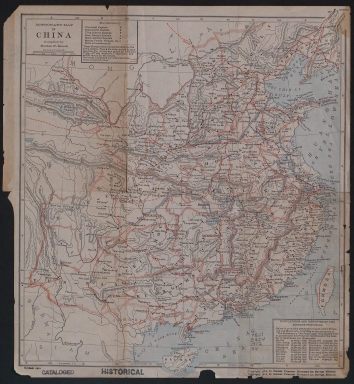
The map is a map of China with all the provincial, department and district capitals marked as well as all existent and projected railways. The number of inhabitants of each province is also given as well as the number per square mile within each province.
|
|
Note:
|
Original is a printed map, 36 x 32 cm.
|
|
Note:
|
Scale line in miles underneath the title.
|
|
Note:
|
Relief shown by hachures.
|
|
Note:
|
Map with graticule.
|
|
Note:
|
The four borders of the map with latitude and longitude lines.
|
|
Note:
|
Map outlined in triple fillet.
|
|
Note:
|
Macao in China maps.
|
|
Geographic Area:
|
China
|
|
Geographic Area:
|
Hainan Island (China)
|
|
Geographic Area:
|
Taiwan
|
|
Provenance:
|
University of California, Los Angeles Library
|
|
Provenance:
|
https://catalog.library.ucla.edu/vwebv/holdingsInfo?bibId=7553172
|
|
Provenance Call No.:
|
G7821.E424 1912 .B4
|
|
MUST holding:
|
https://must.primo.exlibrisgroup.com/permalink/853MUST_INST/171sgkf/alma991003001149505076
|