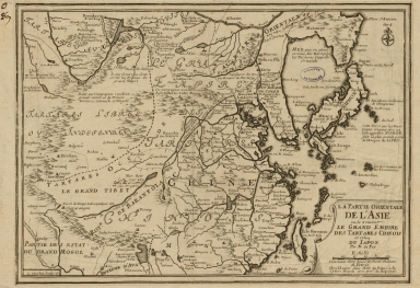
Detail View: Old Maps Collection: La partie orientale de l'Asia ou se trouvent le grand Empire des Tartares Chinois et Celuy du Japon

|
Barcode:
|
3687800354493H
|
|
Title:
|
La partie orientale de l'Asia ou se trouvent le grand Empire des Tartares Chinois et Celuy du Japon
|
|
Contributor:
|
Fer, Nicolás de, 1646-1720, cartographer
|
|
Contributor:
|
Inselin, Charles, fl. 1673-1715, engraver
|
|
Category:
|
General Maps
|
|
Type:
|
Printed
|
|
Language:
|
French
|
|
Create Year:
|
1703
|
|
Scale:
|
[1:12,000,000].
|
|
Physical Map Dimension (cm):
|
23 x 33 cm, on sheet 31 x 41 cm
|
|
Note:
|
Nicolas de Fer was a French cartographer and geographer but also an engraver and publisher. His works focused more on quantity than quality and so geographical errors happened quite often. This particular map includes China, Korea, Japan, Taiwan, Mongolia and northern India. Proper China can be seen with quite a number of toponyms but Mongolia, Korea and Japan are more scarce in toponyms. The island of Hokkaido (Terre d'Yeço) is still connected to the continent. The island of Taiwan is labeled "Isle Formosa ou Bel-Isle" and the Great Wall of China is shown. The map has a quite a number of interesting annotations.
|
|
Note:
|
Original is a copperplate printed map, 26 x 36 cm.
|
|
Note:
|
On the left bottom corner of the map: "C. Inselin Sculpsit".
|
|
Note:
|
Title inside strapwork cartouche on the right bottom corner of the map.
|
|
Note:
|
There is a 4-point compass rose on the right upper corner of the map with a fleur-de-lis indicating north.
|
|
Note:
|
Scale line underneath the title in black and white interchangeably.
|
|
Note:
|
Relief shown pictorially.
|
|
Note:
|
Map outlined in double fillet.
|
|
Note:
|
Macao in China maps.
|
|
Geographic Area:
|
East Indies
|
|
Geographic Area:
|
China
|
|
Geographic Area:
|
Taiwan
|
|
Geographic Area:
|
Mongolia
|
|
Geographic Area:
|
Japan
|
|
Geographic Area:
|
Korea
|
|
Provenance:
|
Archives Nationales de France
|
|
Provenance:
|
https://www.siv.archives-nationales.culture.gouv.fr/siv/IR/FRAN_IR_050187
|
|
Provenance Call No.:
|
NN/170/1
|
|
MUST holding:
|
https://must.primo.exlibrisgroup.com/permalink/853MUST_INST/171sgkf/alma991003001049405076
|