Detail View: Old Maps Collection: Carte hydrographique & chorographique des isles Philippines : dediée à Sa Majesté Catholique, par le Brigadier Don Ferdinand Valdes Tamon, Chevalier de l'ordre de S.t Jaques, Gouverneur & Capitaine Général des dites Isles, dressée par le R. Pere Pierre Murillo Velarde, de la C. de Gieusu sur les Cartes, les Rélations et les Navigations les plus exactes à Manille 1734 par ordre de Sa Majesté
|
Barcode:
|
3687800354492G
|
|
Title:
|
Carte hydrographique & chorographique des isles Philippines : dediée à Sa Majesté Catholique, par le Brigadier Don Ferdinand Valdes Tamon, Chevalier de l'ordre de S.t Jaques, Gouverneur & Capitaine Général des dites Isles, dressée par le R. Pere Pierre Murillo Velarde, de la C. de Gieusu sur les Cartes, les Rélations et les Navigations les plus exactes à Manille 1734 par ordre de Sa Majesté
|
|
Other Title:
|
Carte hydrographique et chorographique des isles Philippines
|
|
Other Title:
|
Hydrographica y chorographica de las Ysles Filipinas
|
|
Contributor:
|
Lowitz, Georg Moriz, 1722-1774, cartographer
|
|
Contributor:
|
Murillo Velarde, Pedro, 1696-1753, bibliografic antecedent
|
|
Contributor:
|
Bagay, Nicolás de la Cruz, 1701-1771, engraver
|
|
Contributor:
|
Valdés y Tamón, Fernando de, 1681-ca. 1741, dedicator
|
|
Contributor:
|
Charles III, King of Spain, 1716-1788, dedicatee
|
|
Contributor:
|
Homann Erben (Firm), publisher
|
|
Category:
|
General Maps
|
|
Type:
|
Printed
|
|
Language:
|
French
|
|
Language:
|
Spanish
|
|
Create Year:
|
1760
|
|
Scale:
|
Scale not given.
|
|
Physical Map Dimension (cm):
|
46 x 54 cm, on sheet 52 x 62 cm
|
|
Note:
|
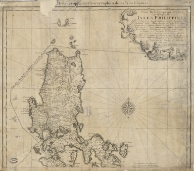
This is Lowitz's two-sheet version of a map of the Philippine Islands by Pedro Murillo Velarde. The map depicts a very detailed view of the islands, with villages, waterways, and historical events marked, it is the most accurate map of the islands to that date. The map combines enormous coastal and topographical details with the attributes of a sea chart, showing the sailing courses for vessels heading to both Spain (Madrid) and New Spain (Mexico), as well as the course taken by Magellan in 1521. To the north is the route of the Acapulco-Manila galleon, which could sail via Cape Boxeador or through the islands. To the south is the track of Ferdinand Magellan, the first European to visit the islands in 1521. He is mentioned in the note cartouche on the left bottom corner which gives a short history of the Europeans in the Philippine Islands. The Velarde Map, the first indigenous engraved map of the Philippines, is a reduced version. In the early 18th century, Philip V had ordered a new map of the Philippines to be prepared and the task fell to Velarde. In Manila in 1734, he produced the most accurate map of the Philippines with the help of local artisans, such as Nicolás de la Cruz Bagay, a Tagalog Indian, engraver. This particular map has been slightly altered in regard to the original.
|
|
Note:
|
Original is a copperplate printed map in two sheets, 49 x 56 cm. This item is incomplete and so only includes the upper sheet.
|
|
Note:
|
Underneath the title cartouche: "L'original est gravé par Nicolas de la Cruz de Bagay, Indien de Tapalos, à Manille l'an 1734". On the upper right corner of the map: "Fol. I."
|
|
Note:
|
Title inside scroll work phytomorphic cartouche on the upper right corner of the map, sided by two figures with nautical measurement instrument, one with a cross-staff and the other with a leadline. With a mermaid playing a sea coral horn on the bottom. There is a 32-point compass rose with a fleur-de-lis indicating north and a flower on the south. The rhumb lines for the principal and half-winds are simple lines and the quarter-winds in dotted lines.
|
|
Note:
|
Relief shown pictorially.
|
|
Note:
|
Map with graticule.
|
|
Note:
|
Latitude and longitude lines on the right and left and top border of the map in black and white interchangeably.
|
|
Note:
|
Map outlined in double fillet.
|
|
Note:
|
Mots of the map is in French with some notes and place names in Spanish.
|
|
Geographic Area:
|
Philippines
|
|
Provenance:
|
Archives Nationales de France
|
|
Provenance:
|
https://www.siv.archives-nationales.culture.gouv.fr/siv/IR/FRAN_IR_050187
|
|
Provenance Call No.:
|
NN/169/72
|
|
MUST holding:
|
https://must.primo.exlibrisgroup.com/permalink/853MUST_INST/171sgkf/alma991003001149805076
|