Detail View: Old Maps Collection: Carte de l'Empire du Japon : dressé sur les auteurs Japonois, sur les Memoires des Portugais et des Hollandois, et en particulier sur ceux des RRPP. de la Comp.e de Jesus
|
Barcode:
|
3687800354491F
|
|
Title:
|
Carte de l'Empire du Japon : dressé sur les auteurs Japonois, sur les Memoires des Portugais et des Hollandois, et en particulier sur ceux des RRPP. de la Comp.e de Jesus
|
|
Contributor:
|
Bellin, Jacques-Nicolas, 1703-1772, cartographer
|
|
Contributor:
|
Dheulland, Guillaume, 17---ca. 1770, engraver
|
|
Category:
|
General Maps
|
|
Type:
|
Printed
|
|
Language:
|
French
|
|
Create Year:
|
1735
|
|
Scale:
|
[1:3,000,000].
|
|
Physical Map Dimension (cm):
|
41 x 54 cm, on sheet 46 x 64 cm
|
|
Note:
|
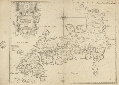
This map depicts the island of Japan showing provinces (delineated via dotted lines), islands, towns, mountains and rivers. It was one of the best maps of Japan from the mid-18th century. The main island of Honshu is named as 'Isle de Nipon', Kyushu is marked 'Isle de Ximo' and Shikoku as 'I. de Xixoco'. The map is however missing the island of Hokkaido that was already standard at the time with the name of Yezo. For Bellin believed Kamchatka to be the same as Hokkaido. The map places an emphasis on the coastlines and water features of the area, including the Korean Sea (Mer de Corée) and the Sea of Japan (Mer du Japon). The various islands are represented in great detail. Bellin cited both Jesuit and Portuguese sources in the creation of this map. He also used a wider variety of sources, including Dutch, Russian, and Japanese sources. However, his main source of information for the map was German traveler Engelbert Kaempfer (1651-1716), who was one of the foremost experts on Japan and Persia in the 17th century. Kaempfer was likely excluded from the citation due to Pierre-François-Xavier de Charlevoix’s (1682-1761) Jesuit background and preference for Jesuit sources.
|
|
Note:
|
Original is a copperplate printed map, 46 x 64 cm.
|
|
Note:
|
Underneath the title cartouche on the left side: "Dheulland Sculp."
|
|
Note:
|
Title inside scroll work phytomorphic cartouche sided by two figures (the one on the right seems like a fighter for it has two swords and a fire gun) and headed by a halo head. There is one full and a half 32-point compass roses on the map with a fleur-de-lis indicating north. The rhumb lines for the principal winds are bold lines, the half-winds in simple lines and the quarter-winds in dotted lines.
|
|
Note:
|
Double scale line underneath the title in Japanese miles and French miles in black and white interchangeably.
|
|
Note:
|
Relief shown pictorially.
|
|
Note:
|
The four borders of the map with latitude and longitude lines in black and white interchangeably.
|
|
Note:
|
Map outlined in double fillet.
|
|
Reference:
|
Walter, L. Japan: a cartographic vision, 81
|
|
Reference:
|
Hubbard. J.C., Japoniae Insulae : the Mapping of Japan: Historical Introduction and Cartobibliography of European Printed Maps of Japan to 1800
|
|
Geographic Area:
|
Japan
|
|
Provenance:
|
Archives Nationales de France
|
|
Provenance:
|
https://www.siv.archives-nationales.culture.gouv.fr/siv/IR/FRAN_IR_050187
|
|
Provenance Call No.:
|
NN/169/13
|
|
MUST holding:
|
https://must.primo.exlibrisgroup.com/permalink/853MUST_INST/171sgkf/alma991003001049605076
|