Detail View: Old Maps Collection: Route du voyage de Canton a Peking.
|
Barcode:
|
3687800354489M
|
|
Title:
|
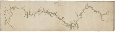
Route du voyage de Canton a Peking.
|
|
Original Title:
|
Rovte du voyage de Canton a Peking
|
|
Category:
|
General Maps
|
|
Type:
|
Manuscript
|
|
Language:
|
French
|
|
Create Year:
|
[17--]
|
|
Scale:
|
Scale not given.
|
|
Physical Map Dimension (cm):
|
17 x 64 cm, on sheet 22 x 68 cm
|
|
Note:
|
This map depicts the only travel route from Guangzhou (Canton) to Beijing (Peking) of the 17th century allowed to foreigns. Macao is written on the left side of the map near small islands of the South China Sea in a non-accurate portrayal. The route would follow the Pearl River until Guangzhou and then to Nanxiong (Namhun) where they would then travel by land until Nanungan (Nangan) where they would then follow the Ganjiang River until Beijing. Major cities near the river courses are marked on the map with a stylization of a small house, usually attached to important places on maps.
|
|
Note:
|
Original is a copperplate printed map, 18 x 66 cm.
|
|
Note:
|
On the upper right corner of the map: "Fol. 27".
|
|
Note:
|
Map oriented with West at the top.
|
|
Note:
|
Relief shown pictorially.
|
|
Note:
|
Map outlined in double fillet.
|
|
Note:
|
Macao in China maps.
|
|
Subject:
|
Description and Travel
|
|
Geographic Area:
|
China
|
|
Provenance:
|
Archives Nationales de France
|
|
Provenance:
|
https://www.siv.archives-nationales.culture.gouv.fr/siv/IR/FRAN_IR_050187
|
|
Provenance Call No.:
|
NN/170/2
|
|
MUST holding:
|
https://must.primo.exlibrisgroup.com/permalink/853MUST_INST/171sgkf/alma991003001049805076
|