Detail View: Old Maps Collection: Carte des costes de Cochinchine Tunquin et partie de celles de la Chine.
|
Barcode:
|
3687800354488L
|
|
Title:
|
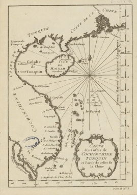
Carte des costes de Cochinchine Tunquin et partie de celles de la Chine.
|
|
Category:
|
General Maps
|
|
Type:
|
Manuscript
|
|
Language:
|
French
|
|
Create Year:
|
[17--]
|
|
Scale:
|
[1:8,000,000].
|
|
Physical Map Dimension (cm):
|
21 x 14 cm, on sheet 30 x 24 cm
|
|
Note:
|
This is a chart of the South China Sea with the south coast of China and the East coast of Vietnam. The Paracel Islands roughly take the center of the map with the triangle of the 'Les Lunettes' or 'Le Cordon de S.t Antoine' on their northeast side. Quite a few toponyms are given on the coast of Vietnam but on the China coast the number of toponyms decreases.
|
|
Note:
|
Original is a copperplate printed map, 25 x 19 cm.
|
|
Note:
|
Title inside scroll work cartouche.
|
|
Note:
|
There is a 32-point compass rose on the map with a fleur-de-lis indicating north.The rhumb lines for the principal winds in bold lines, the half-winds in simple lines and the quarter-winds in dotted lines.
|
|
Note:
|
Vertical scale line on the right side of the map.
|
|
Note:
|
On the bottom right corner of the map: "Tom. II N.º 3".
|
|
Note:
|
The right and bottom borders of the map with latitude and longitude lines in black and white interchangeably.
|
|
Note:
|
Map outlined in simple fillet.
|
|
Note:
|
Macao in East Indies maps.
|
|
Subject:
|
Charts
|
|
Geographic Area:
|
South China Sea
|
|
Geographic Area:
|
China
|
|
Geographic Area:
|
Hainan Island (China)
|
|
Geographic Area:
|
Vietnam
|
|
Geographic Area:
|
Paracel Islands
|
|
Provenance:
|
Archives Nationales de France
|
|
Provenance:
|
https://www.siv.archives-nationales.culture.gouv.fr/siv/IR/FRAN_IR_050187
|
|
Provenance Call No.:
|
NN/170/4
|
|
MUST holding:
|
https://must.primo.exlibrisgroup.com/permalink/853MUST_INST/171sgkf/alma991003001049705076
|